GPS PROCEDURESDOC UPDATED APRIL 2015 PACIFIC GPSBASED MONITORING SYSTEM
GPS PROCEDURESDOC UPDATED APRIL 2015 PACIFIC GPSBASED MONITORING SYSTEM
Operator Information
GPS Procedures.doc Updated: April 2015
Pacific GPS-based Monitoring System (GMS) Monitoring Procedures
Monitoring is required for all operators of aircraft that have received RVSM operational approval. Current monitoring goals should be reviewed for actual requirements; generally 2 or 3 aircraft of each type must be monitored. Monitoring requirements as well as other RVSM information can be found at the following web sites:
FAA RVSM
https://www.faa.gov/air_traffic/separation_standards/rvsm
Pacific Approvals Registry and Monitoring Organization (PARMO)
https://www.faa.gov/air_traffic/separation_standards/parmo/
Airworthiness Approval
In-production or new production aircraft attain airworthiness approval through verification of RVSM eligibility in the Airplane Flight Manual or Type Certificate Data Sheet. In-service aircraft attain airworthiness approval through the application of the type-specific RVSM Service Bulletin. The aircraft engineering requirements vary for individual types or groups of aircraft. These requirements may include upgrades to the air data computers, pitot-static modifications, skin waviness testing, and visual or paint inspections. After airworthiness approval is obtained, the operational approval process is completed by incorporation of RVSM policy and procedures into the training program, manuals, and maintenance program. Monitoring may be conducted after airworthiness approval information has been sent to the PARMO. Only airworthiness approved aircraft will be monitored.
PARMO
The PARMO is responsible for all monitoring activity and the operation of the GMS. CSSI Inc., the GMS support contractor, will assist the PARMO with the monitoring program.
GMS Description
The GMS is comprised of the equipment and procedures to collect and process three required data elements: GPS data, pressure altitude or Mode C data, and meteorological data. The GPS-based Monitoring Unit (GMU) is used to collect the GPS data during the monitoring flight. The PARMO, through the use of the attached Flight Information Form (FIF), will coordinate with the operator the collection of pressure altitude or Mode C data from ATC facilities. The operator will provide pressure altitude data from the digital flight data recorder (DFDR) of the aircraft being monitored. Late transmittal of the FIF and illegible or blank entries will delay processing and the dissemination of results. Meteorological data will be obtained by the PARMO without operator involvement.
Monitoring Flights
Monitoring flights do not need to be conducted in Pacific Airspace. Monitoring can be conducted on scheduled flights, ferry flights, or monitoring-specific flights. To ensure collection of sufficient position data, the flight must be straight and level at any altitude from FL290 to FL410, and should be at least thirty minutes in duration. Monitoring should also be conducted in areas where Mode-C radar data can be retrieved in a timely manner. In addition to Mode-C collected by the PARMO, the operator should provide pressure altitude data from the Digital Flight Data Recorder (DFDR) to the PARMO for Altimetry System Error (ASE) calculation.
GMU Description
The GMU is a portable unit comprised of a Global Positioning System (GPS) receiver, two GPS antennas, temporarily mounted on interior windows, and a laptop computer. The unit requires plug in power from the aircraft (draws 2.0 to 4.0 amperes maximum) and accepts multiple types of power standard to aircraft. The GMU can be installed in the aircraft cockpit or cabin, depending upon aircraft type. Installation time is approximately 15 minutes. For most transport aircraft, the GMU is best installed using the aft cockpit windows. The GMS Monitoring Specialist typically occupies a jump seat to monitor GMU performance. GMU installation is transparent crew operations.
Monitoring Process
Upon receiving airworthiness approval, the operator should contact the PARMO GMS Operations Coordinator to discuss monitoring options. To start the monitoring process the operator should submit the attached Monitoring Application to the PARMO. The Monitoring Application should include all aircraft that will be operated in the Pacific Region. The collection of GPS data with the GMU can be accomplished by a GMS Monitoring Specialist or by an operator representative that has received GMU training. The operator and the PARMO GMS Operations Coordinator will develop a mutually agreed upon plan for monitoring.
The operator will take the necessary steps to retrieve pressure altitude data from the digital flight data recorder (DFDR). The DFDR data should be sent to the PARMO as an electronic file. The specific format of the electronic file and the PARMO DFDR point of contact is contained in the following section.
To conduct the monitoring flight, the Monitoring Specialist or operator representative that has received GMS training, will perform the following tasks:
Submit preflight FIF to PARMO and GMS Support Contractor
Operate GMU
Submit post-flight FIF to PARMO and GMS Support Contractor
Submit GPS data files to GMS Support Contractor
T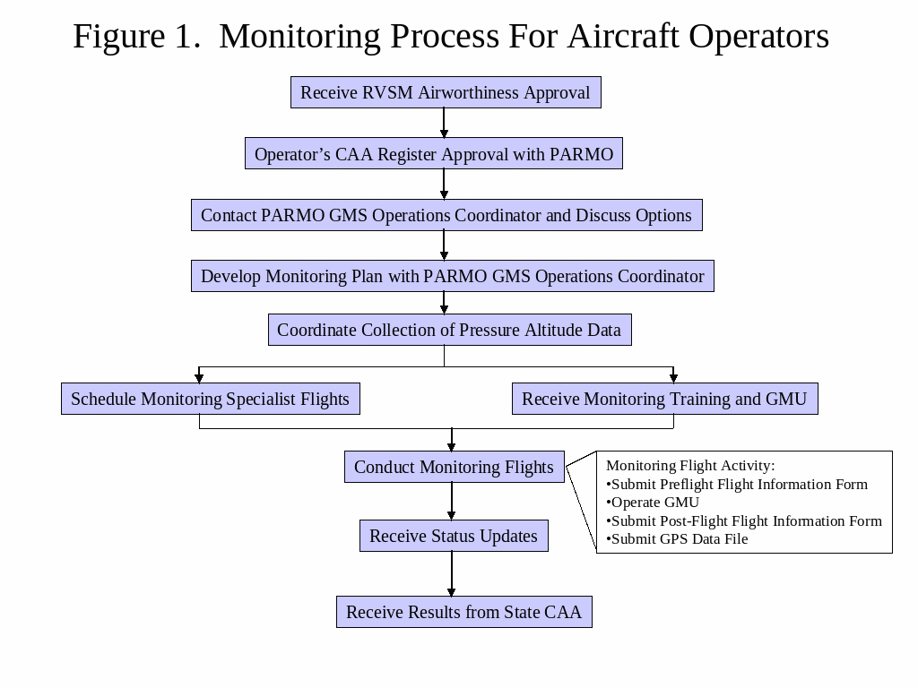
he
Monitoring process from the operator’s perspective is
illustrated in Figure 1. The operator will be notified by a
facsimile memo as the FIF, GPS data file, and pressure altitude data
file move through the post-flight processing steps at the PARMO.
Digital Flight Data Recorder Data
Digital Flight Data Recorder (DFDR) data should contain altitude (ALT) expressed in feet with corresponding time (UTC) expressed in hours, minutes, and seconds HH/MM/SS to two decimal places and the aircraft transponder code (TXP). Altitude data submitted to the PARMO should have reports with 12-second or better intervals.
Providing aircraft position data for each level of flight further aids the PARMO in ASE calculation. Position data can be provided in latitude/longitude or range/azimuth (x/y) formats. A reference point is helpful when providing position data in the range/azimuth (x/y) format. Please provide the units of measurement for each piece of position data submitted to the PARMO.
DFDR Data Samples:
Range/Azimuth (X/Y) Data
TXP X Y ALT HH/MM/SS
5113 -284.969 197.938 36900 13/23/21.00
Latitude/Longitude Data
TXP LAT LON ALT HH/MM/SS
2241 54.833 4.494E 28000 17/57/42.00
2241 54.826 4.489E 28000 17/57/47.00
Sending DFDR data to the PARMO as an ASCII or text file via e-mail is recommended.
PARMO DFDR Point of Contact:
Phone: 1+609-485-5102
Fax: 1+609-485-5117
E-mail: [email protected]
Monitoring Post-Flight Information
After completion of the monitoring flight, the GPS data will be processed by the GMS Contractor and forwarded to PARMO. The operator will be advised by fax of the processing status of the data file. For the computation of the ASE, Meteorological data and Mode C data will be collected and merged with the GPS data at PARMO. Final ASE results should be available from PARMO within two weeks of the flight. The results will provided and posted on the PARMO web site.
PARMO GMS Contacts:
PARMO Activities Coordinator
Phone: 1+609-485-5678
Fax: 1+609-485-5078
Email: parmo@faa.gov
CSSI Inc., PARMO GMS Operations Coordinator:
Phone: 1+202-863-7426
Fax: 1+202-863-2398
Email: [email protected]
REDUCED VERTICAL SEPARATION MINIMUM (RVSM)
MONITORING APPLICATION
(Return completed form by fax to 1+609-485-5078 and 1+202-863-2398)
Operator Name:_________________________________________________________________________________________
Address:_______________________________________________________________________________________________
_______________________________________________________________________________________________________
Operator Primary Point of Contact
Name:_________________________________________________________Title:_____________________________________
Telephone Number:_________________________Fax Number: ______________________Email Address:_________________
Secondary Point of Contact
Name:_______________________________________________________Title:_______________________________________
Telephone Number:________________________Fax Number: ______________________Email Address:__________________
Civil Aviation Authority Contact
Name:_______________________________________________________Title:_______________________________________
Telephone Number:________________________Fax Number: ______________________Email Address:__________________
________________________________________________________________________________________________________
AIRCRAFT INFORMATION
(Please be sure to include data for the ENTIRE fleet)
|
Aircraft Model |
Registration Number |
Serial Number |
|
|
|
|
|
|
|
|
|
|
|
|
|
|
|
|
|
|
|
|
|
|
|
|
|
|
|
|
|
|
|
|
|
|
|
|
|
|
|
|
|
|
|
|
|
|
|
|
|
|
|
|
|
|
|
|
|
|
|
|
PARMO
USE
F
Please Fax to the PARMO at 1+609 485 5078 and 1+202-863-2398,
24 hours prior to flight and within 6 hours of landing.
|
INFORMATION TO BE RECORDED PRIOR TO FLIGHT |
|||||||||||||
|
Airline/Operator: |
GMU Container Number: |
|
|||||||||||
|
Point of Contact for Operator: Name: Phone: Fax: |
|||||||||||||
|
Aircraft Type/Series: |
Aircraft Registration Number: |
||||||||||||
|
Call Sign: |
Airframe Serial Number: |
||||||||||||
|
Planned: Origin: Departure Date (UTC): Departure Time (UTC): |
|||||||||||||
|
Planned: Destination: Arrival Date (UTC): Arrival Time (UTC): |
|||||||||||||
|
Installer (Name/Org.): |
Retriever (Name/Org.): |
||||||||||||
|
Mode S Equipped (Yes/No): Separation Between Mounted Antennas (ft.): |
|||||||||||||
|
Installer/Operator Comments:
|
|||||||||||||
|
INFORMATION TO BE RECORDED BY FLIGHT CREW/GMU OPERATOR |
|||||||||||||
|
Data Collection: |
Start Date (UTC): |
Start Time (UTC): |
|||||||||||
|
GMU File Name: |
|||||||||||||
|
Departure Time (UTC): |
Origin (ICAO ID): |
|
|||||||||||
|
Please record the requested information as soon as practical when: Aircraft is first established in level flight at or above FL 290, or The ATC assigned transponder code is changed at or above FL 290, or There is a flight level change and aircraft remains at or above FL 290, or An autopilot change is initiated at or above FL 290, or The ARTCC or FIR changes. |
|||||||||||||
|
Time |
Assigned |
Mach/Air |
Xpndr |
Altimeter Reading |
Autopilot (L, R, C) |
FMS/PMS |
ARTCC/FIR |
||||||
|
(UTC) |
FL |
Speed |
Code/Source |
Pilot |
Co-pilot |
Pilot |
Co-pilot |
(Y/N) |
(ICAO ID) |
||||
|
|
|
|
|
|
|
|
|
|
|
||||
|
|
|
|
|
|
|
|
|
|
|
||||
|
|
|
|
|
|
|
|
|
|
|
||||
|
|
|
|
|
|
|
|
|
|
|
||||
|
|
|
|
|
|
|
|
|
|
|
||||
|
|
|
|
|
|
|
|
|
|
|
||||
|
|
|
|
|
|
|
|
|
|
|
||||
|
Data Collection: |
End Date (UTC): |
End Time (UTC): |
|||||||||||
|
Arrival Time (UTC): |
Destination ICAO (ID): |
|
|||||||||||
|
Comments on flight conditions affecting height keeping performance, i.e. turb, and location
|
|||||||||||||
Tags: april 2015, gpsbased, system, monitoring, updated, april, proceduresdoc, pacific
- HOW TO SET UP POP3 WITH YOUR EMAIL ADDRESS
- 2 021 MOUNTAIN TOUR NONMEMBER INFO FORM FIRST NAME
- GENERAL SCHEME OF LECTURES IN CHEMISTRY 20152016 SUBJECT
- CLASS 9 ATYPICAL BACTERIA LEGIONELLA CHLAMYDIA CHLAMYDOPHILA MYCOPLASMA AND
- 6 PROVIDENCIA EMITIDA POR EL TRIBUNAL DE
- UNDERVISNINGSVURDERING – NOEN JURIDISKE FORHOLD HOVEDINNHOLD HER FÅR DU
- for 19991027 nr 1166 Instruks for Tilsyn og Kontroll
- POST OFFICE THEME PLANNING HOW DOES THIS THEME RELATE
- HOMEWORK 6 EARTHQUAKE LOCATION EPSC 1021 SPRING 2007 DUE
- TJELESNI RAZVOJ U RANOM DJETINJSTVU RAST TIJELA VELIKA
- CHAPTER 13 COUNSELING OLDER FATHERS RORY REMER NEIL MASSOTH
- REQUIRED LETTER (SAMPLE) NOTIFICACIÓN A LOS PADRES SOBRE LA
- UAB „KAUNO AUTOBUSAI“ DARBUOTOJŲ PROFESINĖS SĄJUNGOS 25OSIOS ATASKAITINĖS KONFERENCIJOS
- INTRODUKTIONSUDDANNELSEN INTRODUKTIONSSAMTALEN GENERELT DER AFSÆTTES 1 TIME I ROLIGE
- DIREKTORAT ZA PRORAČUN SEKTOR ZA SISTEM FINANCIRANJA LOKALNIH SKUPNOSTI
- GOOD TIDINGS OF GREAT JOY LUKE 2 10 CHRISTMAS
- UNA REFLEXIÓN SOBRE LA INSOSTENIBILIDAD DE LAS ACTIVIDADES TURÍSTICAS
- PAGE 0 OF 1 CORPORATION FINED FOR NOT LODGING
- DAVČNE OLAJŠAVE ZA VLAGANJA V RAZISKAVE IN RAZVOJ SMERNICE
- ANSWERS TO SPECIMEN EXAM (THESE ARE SKELETON ANSWERS ONLY
- IRTG LECTURES DATE LECTURER AFFILIATION TITLE 08092014 PROF DR
- UMOWA DZIERŻAWY GRUNTU NR……………………… ZAWARTA DNIA …………… R W
- MAPA AKTYWNOŚCI LOKALNEJ ORGANIZACJI POZARZĄDOWYCH I INICJATYW NA TERENIE
- T RIBUNAL DE SELECCIÓN PARA BOLSA DE TRABAJO DE
- POREĐENJE ONLINE SISTEMA I OFFLINE BRAVE U VRATIMA 1
- ZAŁĄCZNIK NR 25 DO UCHWAŁY NR XLX 18 RADY
- BOGOTÁ SEÑOR JORGE HUMBERTO MANTILLA SERRANO SECRETARIO GENERAL CÁMARA
- ANNEXE C PRESCRIPTIONS DE BASE POUR PLANIFIER LA
- WHO IS FATHER CHRISTMAS? FATHER CHRISTMAS IS OUR VERSION
- Ðïࡱáþÿ ¥á` пx86bjbj¡¡ x89ããx9dèÿÿÿÿÿÿ¤\\p p p p x94
 CARACTERIZACIÓN DEL CLIMA ORGANIZACIONAL EN LA EMPRESA AEROVARADERO SA
 DECRETO POR EL QUE SE CREA CON CARÁCTER DE
 GRAD RIJEKA ODJEL GRADSKE UPRAVE ZA KOMUNALNI SUSTAV NA
 CONTACTO IGNACIO VILLEGAS RESPONSABLE DE PRENSA TEL +34 91
 ESQUADRIAS ESPECIAIS GF A GF É A LINHA DE
OSNOVNA ŠKOLA „DESANKA MAKSIMOVIĆ“ TRN PISMENA PRIPREMA ZA ČAS
FORMULARIO PARA LA MODIFICACIÓN DE LOS DATOS DE UN
PREDMET PRIJEDLOG IZMJENE I DOPUNE PRAVILNIKA O KRITERIJIMA I
PODELA KNJIGA IIIII I IV GODINA SVI STUDENTI KOJI
PERANAN PENYIDIK KPK DI DALAM PEMBERANTASAN TINDAK PIDANA KORUPSI
RESOLUCIÓN 39152018 DE 26 DE NOVIEMBRE DEL DIRECTOR DEL
 DIE NACHFOLGENDEN LISTEN SIND DER BROSCHÜRE „ÜBERFACHLICHE KOMPETENZEN“ ENTNOMMEN
VAM – LITERATURE KEY DOCUMENTS AND LITERATURE ON FOOD
TEMA 21 LAS CUENTAS ANUALES CONCEPTO UNO DE
 TERMS OF REFERENCE INDIVIDUAL CONSULTANT SURVEILLANCE ASSESSMENTS MALARIA SURVEILLANCE
 WO AMENDMENT 280020072 EFFECTIVE DATE 04042007 DURATION THIS AMENDMENT
SEPTEMBER 17 2001 STATE WATER RESOURCES CONTROL BOARD
APROVECHAMIENTOS CINEGÉTICOS Y PISCÍCOLAS ESTE MÓDULO PROFESIONAL SE IMPARTE
 FACTIBILIDAD “ MEJORAMIENTO INSTALACIONES DEPORTIVAS Y RECREATIVAS INSTALACIÓN
 “UN CAFÈ AMB PABLO GUTIÉRREZ” CICLO DE CAFÉS COLOQUIOS
