CHOOSING CONTROL POINTS RMS (ROOT MEAN SQUARE) ERROR AND
12 CHOOSING THE RIGHT LEADFREE SOLDER FOR HIREL PRINTED2021 MEMBERSHIP OPTIONS THANK YOU FOR CHOOSING YOU’RE PLAYING
4 CHOOSING A METADATA STANDARD FOR YOUR DIGITAL PROJECT
APPLICATION FORM FOR JOINING THE CHOOSING OF ASICON 2021
BLUETOOTH CAR CHARGER BC71 MANUAL THANK YOU FOR CHOOSING
BLUETOOTH WATCH INSTRUCTIONS THANK YOU FOR CHOOSING OUR WATCH
Choosing Control Point, RMS (Root Mean Square) Error, and Image Rectification
CHOOSING CONTROL POINTS, RMS (ROOT MEAN SQUARE) ERROR,
AND IMAGE RECTIFICATION
Modified from Smith (2006), MicroImages, Inc., Lincoln, Nebraska (http://gisteam.de/ftp/Tutorial/rpcortho.pdf
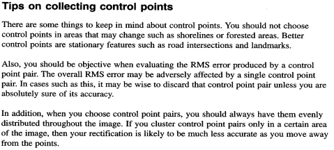
Tips on Selecting Control Points
Mean Deviation values provide measures of the fit of the entire set of control points to the rectified image model as a whole. These values change with any change in the control points.
Evaluating Control Points
You can use the individual control point residuals and the RMS error statistics shown in the Georeference windows to help judge the accuracy of your control points. However, this is a subjective procedure, and there are no rigid guidelines. Ideally, you would like the point residuals to be less than the cell (pixel) size of the image, but you may only be able to approximate this level of accuracy. A large error residual for a particular point may indicate that you made a blunder of some sort. You may have incorrectly recorded a GPS map coordinate in the field, mistyped a value when entering point coordinates, or placed the point in the wrong location in the Input or Reference view. If you can’t identify an obvious source of error or don’t have the information to correct it, try empirically removing large RMS-value error points from the rectification process, and recalibrate the image to see if the RMS-error significantly improves. If you find there is dramatic improvement, you may want to delete the anomalous point.
However, remember that residuals are computed from a global best fit to the entire set of active points. All points contribute equally to this procedure, so the result is influenced by the distribution of points. A control point may have a high residual error because it is isolated from other points that are more clustered together, and you usually need to retain such isolated points to provide adequate coverage of the image. Don’t assume that the point with the highest residual is necessarily the “worst point” in the set. And residuals do not reveal systematic error that may affect all points equally, such as choosing the wrong datum.
If you have a sufficient number of control points that you believe are accurate, you can reserve some of them to use as test points to check the quality of your control point set. First enter just the control points, check the residuals, and edit or delete any problem points. Then enter the test points and set each of them to be inactive. Since your “test” points were not used to develop the active point model, they represent an independent test of the accuracy of your control points. If the RMS error and individual point residuals for your test points are small (comparable in size to those for the active points), then you probably have a suitably accurate set of control points to perform the orthorectification.
More Information on Photo Registration and Image Mosaicing
(From http://www.gallatin.mt.gov/Public_Documents/GallatinCoMT_WQDReports/S00B0E9EE-02022DA5.4/Sect%205_Development%20of%20Orthorectified%20CIR%20Imagery.pdf)
The majority of time spent orthorectifying the photographs was spent obtaining ground
control and tie points used to calculate the exterior orientation of the model. The ground
control came entirely from points on 1995 black and white U.S. Geological Survey DOQs.
The horizontal accuracy of these DOQs followed the National Map Accuracy Specifications
that 90% of the points on image are within 40 feet of their true position. A total of 1082
ground control points were used for the project area, providing an even distribution of control
throughout the project area. The root mean square value (RMS) for the project area was: X-
1.27 meters and for the Y-1.28 meters. The highest RMS value for a ground control point
accepted in the model was 5 meters, (in a few locations where there was a large discrepancy
in accuracy between overlapping DOQs).
The other labor-intensive step was to obtain tie points between the images. A total of 1075
tie points were selected for the project area. The tie points help the computer recognize
where the aerial photographs overlap and provide another point of reference by the software.
The RMS score for the tie points was as follows: X-.10 meters, Y-.07 meters. After all the
ground control points and tie points were established the software was able to generate
orthophotos from each of the raw TIFF images.
The orthogeneration process created a single image (orthophoto) at a time, representing a
subsetted area of each individual scanned image. The image created was a subset of the
entire scanned photo so as to use only the most accurate portion of each aerial photograph
(which is a towards the center) and so as not to include the periphery features, such as
fiducial marks in the scanned image. It was possible to subset considerably as there was an
average of 60% endlap and 30% sidelap for each photograph.
For vertical control 30-meter DEM data obtained from the USGS National Elevation
Database was used in the orthorectification software. The DEM data were used by the
processing software to adjust the horizontal position geometrically for topographic
displacement. As a quality control measure for the project, each individual image created
was swiped with the 1995 USGS black and white DOQ coverage for the same area to
examine for inconsistencies in the images. The most common source of error came from
points that were sharing overlapping positions on DOQs.
After the individual orthophotos were created it was necessary to mosaic the images to make
the final DOQs, which are mosaics of individual orthophotos. Mosaics were created that
would cover the same area as the corresponding USGS 7.5-minute quadrangles. This process
was completed using the PCI GeomaticsTM software, which performed the difficult task of
choosing the best possible cut-lines in the overlapping images to most effectively produce a
15 seamless appearance on the final mosaic. The computer selected the portions in overlapping
photos that had the highest brightness value, which helped to eliminate shadows and dark
areas. The mosaics created were larger than the desired quadrangle and it was necessary to
subset (trim) the mosaics to match the 7.5-minute quadrangle boundaries. The images were
cut to the NAD 83 tics on the 7.5-minute quadrangles to create the final DOQ maps.
CHOOSING A COLLEGE MAJOR HOW TO CHART YOUR IDEAL
CHOOSING A DVD PLAYER IF YOU HAVE A SIGHT
CHOOSING A NURSING HOME HOW DO I CHOOSE A
Tags: (root mean, (root, choosing, control, error, square), points
- LATVIJAS REPUBLIKA DAUGAVPILS NOVADA DOME 2010GADA 21JANVĀRĪ SAISTOŠIE NOTEIKUMI
- CLIMA Y TIEMPO CLIMÁTICO EL CLIMA ES EL VALOR
- PRVNÍ STÁTNÍ ÚTVARY NA NAŠEM ÚZEMÍ HISTORICKY NEJSTARŠÍM
- MARHABA ERASMUS MUNDUS LOT 3 20140653001001 F UNDED BY
- POKYNY CHOVATELŮM KTEŘÍ PODLÉHAJÍ SCHVÁLENÍ A REGISTRACI TYTO POKYNY
- © EUROPEAN UNION 2014 JORNADA INFORMATIVA OPORTUNIDADES INDUSTRIALES EN
- H UMAN RIGHTS OFFICE INTERNATIONAL INSTITUTE MARIA AUSILIATRICE
- MUZEJSKI DOKUMENTACIJSKI CENTAR REGISTAR MUZEJA GALERIJA I ZBIRKI U
- ÚČASTNICKÁ SMLOUVA PRO FIREMNÍ ZÁKAZNÍKY – HROMADNÝ FORMULÁŘ ZÁKAZNICKÉ
- COMMON GROUND A CROSSCULTURAL SELFDIRECTED LEARNER’S INTERNET GUIDE INDIVIDUAL
- CONTOH SURAT PERMOHONAN TANGGAL PERIHAL PERMOHONAN SURAT
- ANA TERESA TORRES ESPÍRITU INDOMABLE DE LA LITERATURA VENEZOLANA
- Revisando el Teatro Clásico Español la Refundición de Comedias
- 12 REVISIÓN SISTEMÁTICA DE LA EVIDENCIA DE EFECTOS PROARRÍTMICOS
- RELIABILITY COMMITTEE ATTACHED TO THE BOARD OF DIRECTORS OF
- INFORME Nº DFOEGU 82005 30 DE JUNIO 2005 DIVISIÓN
- REQUEST FOR COPY OF OWNERS CORPORATION CERTIFICATE OWNERS
- EJERCICIOS SOBRE PROBABILIDADES UCA – DPT MATEMÁTICA 1 SE
- E L DIA DE LOS MUERTOS INTRODUCCIÓN ¿SABES QUÉ
- JUEVES 1 DE ENERO DE 2015 DIARIO OFICIAL 0
- NZQA UNIT STANDARD 9005 VERSION 5 PAGE 3 OF
- MIEJSCE NA WKLEJENIE FOTOGRAFII KWESTIONARIUSZ OSOBOWY 1 IMIĘ (IMIONA)
- EVALUACIÓN DE ACTITUDES DISCRIMINATIVAS Y PREJUICIOS HACIA DIVERSAS POBLACIONES
- MANTENIMIENTO DE EQUIPOS INFORMÁTICOS PROGRAMA DE PRÁCTICAS CURSO 200102
- THE KOREAN BIOCHIP SOCIETY THE KOREA SCIENCE AND TECHNOLOGY
- FOSTERING SELFCONTROL IN STUDENTS AGENDA 1 THE DIFFERENCE BETWEEN
- C ODATA HANDBOEK NG REGIONALE NETBEHEERDERS GAS UITGAVE MAART
- ÍNDICE DE ORDENANZAS REGULADORAS CAPITULO I GENERALIDADES ARTÍCULO
- ERFINDERNENNUNG FÜR DIE HIERNACH NÄHER BEZEICHNETE PATENTANMELDUNG WIRD (WERDEN)
- OTTAWA DIRECTORY OF ASD SERVICES FOR CHILDREN AND ADULTS
LEY MEDIANTE LA CUAL SE CONCEDE UN AUMENTO DE
 OCR FAQ’S QUESTIONS 1 SHIPPING AND MIXING HOW
 CGRAN CAPITAN16 30500 MOLINA DE SEGURA (MURCIA) EMAIL
 HIGH SCHOOL EDUCATION COMMISSION OF THE STATES • 700
NZQA UNIT STANDARD 30101 VERSION 2 PAGE 4 OF
2016 MIDWEST CHALLENGE JANUARY 2324 2016 UNIVERSITY OF
 ON JOINT MOTION OF MR ROBERTS SECONDED BY MS
DATE CLAIMANT NAME CLAIMANT STREET ADDRESS CLAIMANT CITY
in a Perfect World What is the Ideal Relationship
PAPERS PUBLISHED IN CMC FULL PAPERS CAN BE DOWNLOADED
MODELO ORIENTATIVO DE CERTIFICACIÓN PARA NOMEAMENTOS E CESAMENTOS (TOTAL
 SPINYTAILED MONITORGOANNA VARANUS ACANTHURUS OTHER NAMESACKIE OR RIDGETAILED MONITORGOANNA
 C HILDCARE VOUCHERS WE OFFER CHILDCARE VOUCHERS THROUGH
PODER JUDICIÁRIO TRIBUNAL REGIONAL FEDERAL DA PRIMEIRA REGIÃO FLS1616
 LA CNMC MODERA EL CRECIMIENTO DEL CANON PARA 2017
EVITAR LAS REVOLUCIONES CULTURALES EL DURO PERIODO HISTÓRICO QUE
 AL VIEJO RIO PARANA DISCO MUNDIALMENTE AÑO 1967 SELLO
ii Przedmiot Historii Gospodarczej Empiryczne i Normatywne Stanowisko w
IN LOVING MEMORY OF NAME OF DECEASED BORN JANUARY
 TEKS UCAPAN YANG BERHORMAT DATO’ HAJI ABD LATIFF BIN
