THE UTILITY OF GIS ELEMENTS IN WATER MONITORING ACTIVITY
(1) PROFORMA FOR UNIFORM FEEDBACK ON UTILITY OF INFORMATIONS11 HUD UTILITY MODEL INSTRUCTIONS I INTRODUCTION THE HUD
11152021 UTILITY FACILITIES ON BRIDGES PAGE 1 OF 1
2 FOR PUBLIC DISTRIBUTION 20102012 WISCONSIN UTILITY TERRAIN VEHICLE
65407 CHAPTER 407 PAGE 7 65407 PUBLIC UTILITY COMMISSION
65625 CHAPTER 1 PAGE 12 65 PUBLIC UTILITY COMMISSION
The utility of GIS elements in water monitoring activity
The utility of GIS elements in water monitoring activity
Titu Bojin, Vlaicu Ionel, Diana Cristescu, Alina Blaj
Romanian Water Authority – Water Department Banat, Timisoara, Romania,
e-mail : [email protected]
Abstract: The paper presents the importance of GIS elements in the field of water management.
The paper is also a review of water monitoring activity in Romania.
Keywords: bodies water, water monitoring, Water Framework Directive
Die Verwendung der GIS-Elemente in die Wasserbeobachtungstätigkeit
Zusammenfassung: Die Arbeit zeigt die Bedeutung der Benutzung von GIS-Elemente für das Wassermanagement. Diese Arbeit macht eine Vorführung der Wasserbeobachtungstätigkeit in rumänische Gewässer.
Schlüsselworte: WasserKörper, wasser monitoring, Europäischen Wasserrahmen Richtlinie
Banat Hydrografical Area is positioned in the South West part of Romania. Occupies an area of 18.320 km2 from Romania territory.
Total water resources of Banat Hydrografical Area is 1.118.350 x 103 m3. From these, 608.350 x 10³ m3 is representative by surface water resources and 510.000 x 10³ m3 is representative by groundwater (Table 1).
Table 1. Water resources of Banat Hydrografical Area
|
Water resources |
Source of water |
Quantity (m3) |
||
|
Surface water resources |
Assured in natural regime (m3) |
Supplementary assured in reservoirs (m3) |
Assured by recirculation (m3) |
608.350 x 10³ |
|
313.000 x 10³ |
290.350 x 10³ |
5000 x 103 |
||
|
Groundwater |
- |
- |
- |
510.000 x 10³ |
|
Total water resources |
- |
- |
- |
1.118.350 x 103 |
The network of monitoring in Banat Hydrografical Area include 30 sections of first order and 10 sections of second order (Figure 1).
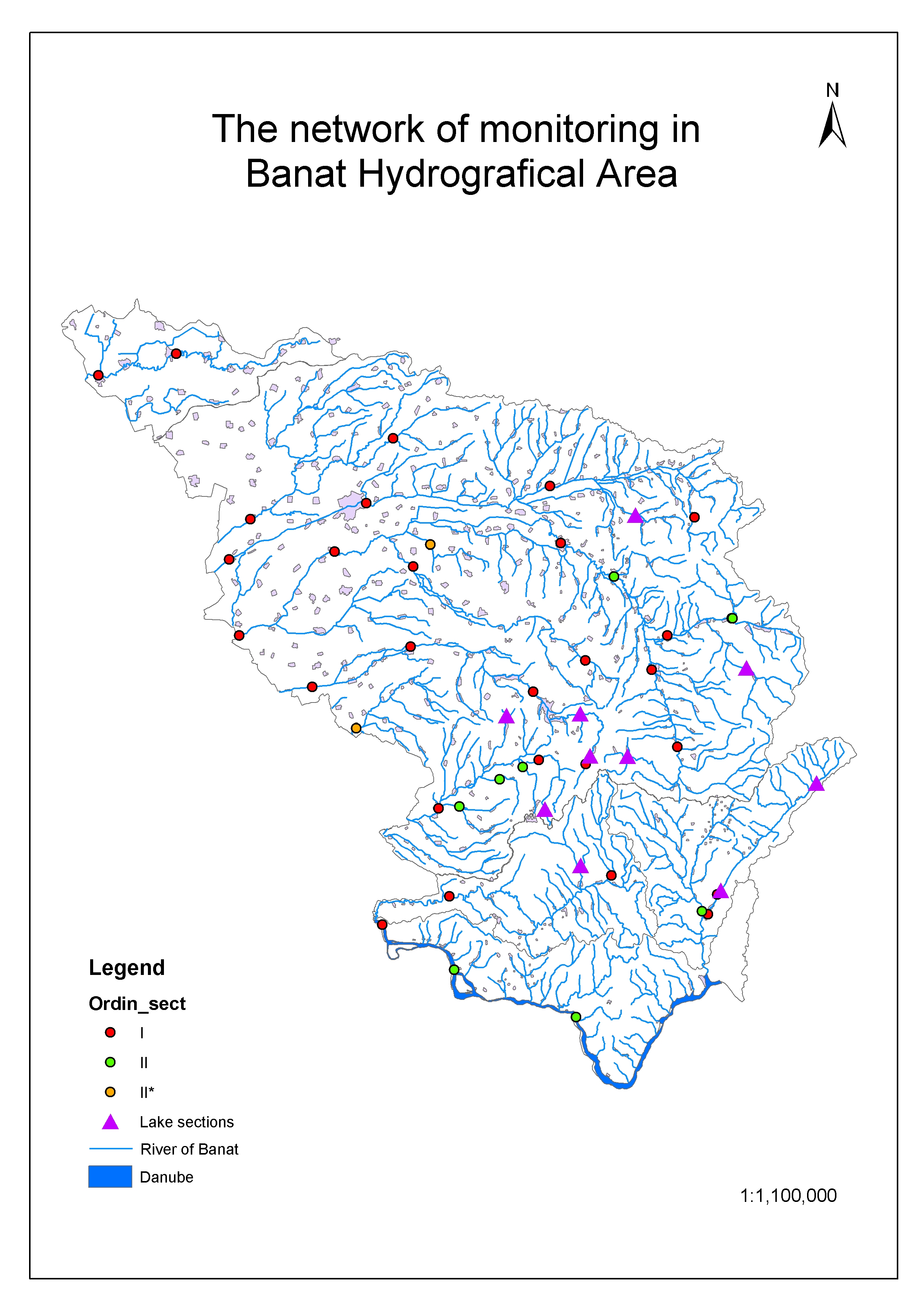 Figure
1. The network of monitoring in Banat Hydrografical
Area
Figure
1. The network of monitoring in Banat Hydrografical
Area
Supplementary it was add still 10 sections of references at monitoring network for definite the water typology.
For enable the status to be accurately described and compared to environmental objectives has been introduced the concept of “water bodies”.
Body of surface water means a discrete and significant element of surface water such as a lake, a reservoir, a stream, river or canal, a transitional water or a stretch of coastal water (Article 2.10 of Water Framework Directive).
The parameters used for identification of water bodies were:
Discrete element – for a surface water body to be a discrete element of surface water, they must not overlap with each other or be composed of elements of surface water that are not contiguous.
Surface water categories - a surface water body must not be split between different surface water categories, it must be of one category.
Typology - a surface water body must not cross the boundaries between surface water body types. It must be of one or another since one purpose of characterizing surface water bodies it to differentiate them into types.
Physical characteristics delineating discrete and and significant elements – physical features (geographical or hydromorphological) that are likely to be significant in relation to the objectives of Water Framework Directive should be used to identify discrete elements of surface water.
Heavily modified and artificial water bodies - heavily modified water bodies may be identified and designated where good ecological status is not being achieved because of impacts on the hydromorphological characteristics of a surface water resulting from physical alterations.
The boundaries of heavily modified water bodies are primarily delineated by the extent of changes to the hydromorphological characteristics that result from physical alterations by human activity and prevent the achievement of good ecological status.
Protected areas – this is an additional criterion for identifications of bodies water. The boundaries of water bodies and protected areas will, in most cases, not coincide because both geographical areas are being defined for different purposes on the basis of different criteria. In case a water body would not fully be inside or outside a protected area, it may be considered to sub-divide the water bodies into two parts so that the boundaries coincide.
A suggest for small elements of surface water is to:
Include small elements of surface water as part of a contiguous larger water body of the same surface water category and of the same type, where possible.
Where this is not possible, screen small elements of surface water for identification as water bodies according to their significance in the context of the Directive’s purposes and provisions (e.g. ecological importance; importance to the objectives of a protected area). In such case, small elements belonging to the same category and type, influenced by the same pressure category and level and having an influence on another well-delimited water body, may be grouped for assessment and reporting purposes.
Considered the qualitative category, the water bodies can be :
water bodies modified qualitative;
water bodies not modified qualitative.
Fallow this elements in Banat Hydrografical Area it was to identified next surface water bodies (Figure 2).

Figure 2. Water bodies of Banat Hydrografical Area
References
Common Implementation Strategy for the Water Framework Directive (2000/60/EC), Identification of water bodies, horizontal guidance, 15 January 2003
Methodology of River Management Plan - 2003
Water Framework Directive (WFD) – (2000/60/EC), 22 December 2000
APPLICATION FOR DECORATIVE TEMPORARY ATTACHMENTS TO UTILITY POLES FREQUENTLY
APPLICATIONPERMIT TO CONSTRUCT OPERATE AND MAINTAIN UTILITY FACILITIES ON
BILLING AND COLLECTING UTILITY FEES CITY ATTORNEYS CONFERENCE MARCH
Tags: activity titu, human activity, water, elements, monitoring, utility, activity
- CROSSMATCHING MULTIPLE SPATIAL OBSERVATIONS AND DEALING WITH MISSING DATA
- THE SECRETARY THE FRIENDS OF ST PAUL’S CATHEDRAL THE
- LA GESTIÓN DE STOCKS EL MODELO DETERMINISTA EN EL
- VADODARA (R &B) CIRCLE VADODARA STATEMENT SHOWING THE STATE
- 5 LEIEAVTALE 1 PARTENE UTLEIER UTLEIER ORGANISASJONSNUMMER XXXXXXXXX ADRESSE
- R EGION NORRBOTTEN LAPONIA HÄLSOCENTRAL VACCINATIONSJOURNAL FÖR UTLANDSRESA SID
- ÖN DENETİM RAPORU DENETLEME İLE İLGILI BILGILER GÖREV ONAYI
- U NITED NATIONS NATIONS UNIES DIVISION DE L’ANALYSE DES
- EN EL MUNICIPIO DE DEPARTAMENTO DE A
- QUÍMICA 2º BACHILLERATO IES LA MAGDALENA AVILÉS ASTURIAS MODELOS
- SALA DE CASACIÓN LABORAL CARLOS ERNESTO MOLINA MONSALVE MAGISTRADO
- CAPÍTULO XVI CASOS CLÍNICOS EN EL LABORATORIO DE HEMATOLOGÍA
- ATTENDANCE DUES GUIDANCE FOR PROPRIETORS USES OF ATTENDANCE DUES
- EANNEX 4 QUALITY MAPPING EXERCISE PROCESS AND DOCUMENTATION
- ENVIRONMENTAL BEST MANAGEMENT PRACTICE BMP NO 203 TAILING
- HÄR KOMMER ANTECKNINGAR FRÅN MÖTET 110314 NÄRVARANDE MARIA (LINSAN
- OLÁ PESSOAL VAMOS CONTINUAR COM A PREPARAÇÃO DO
- UCHWAŁA XXXVI ZJAZDU ZHP Z DNIA 6 GRUDNIA 2009
- REFERENCIA NULIDAD Y RESTABLECIMIENTO DEL DERECHO LABORAL DEMANDANTES ZORAIDA
- SECTION 08360 [08 36 13] SECTIONAL OVERHEAD DOORS DISPLAY
- 23 BALANCE OF PAYMENTS STATISTICS METHODOLOGY TABLE
- MEDIDAS DE POSICIÓN CENTRAL DANNY PERICH C LAS MEDIDAS
- SAN FERNANDO DEL VALLE DE CATAMARCA REF PUBLICACIÓN PERIODÍSTICA
- B ERGEN KOMMUNE BYRÅDSAVDELING FOR MILJØ OG BYUTVIKLING NOTAT
- INDICADORES DE COHESIÓN GRUPAL A CONSIDERAR PARA SU DIAGNÓSTICO
- ZASADY POZYSKIWANIA I WYDATKOWANIA ŚRODKÓW NA DZIAŁALNOŚĆ STATUTOWĄ (DOTACJA
- CHRONOLOGY OF BOSTON & MAINE MAINE CENTRAL AND BANGOR
- E230308EN ANSWER GIVEN BY MS FERREROWALDNER ON BEHALF OF
- LEONARDO PARTNERSÉGEK EGÉSZ ÉLETEN ÁT TARTÓ TANULÁS PROGRAM LEONARDO
- ŠIAULIŲ UNIVERSITETAS SOCIALINIŲ MOKSLŲ FAKULTETAS KAIMO PLĖTROS TYRIMŲ CENTRAS
TUS RIESGOS ADQUIRIR O TRANSMITIR UNA INFECCION DE TRANSMISION
 MODULO DI ISCRIZIONE UNICO CORSI TRIENNALI IO SOTTOSCRITTOA ……………………………………………………………………………………………………………………………………………………………………
EWIDENCJA STOWARZYSZEŃ ZWYKŁYCH (OBOWIĄZUJE OD 20 MAJA 2016 R)
PSY 531 READING AND DISCUSSION GUIDE FOR FEBRUARY 27
25 A NEM VAGYONI KÁR MEGTÉRÍTÉSE IRÁNTI KÖVETELÉSEK ELBÍRÁLÁSÁNAK
1ST MINUTES OF FINAL YEAR PROJECT DATE 29TH OCTOBER
 TRABAJAN EN SUS 4 EQUIPOS DE LA GIRA ESCOGEN
 PGR13 A PPOINTMENT OF EXAMINERS (DOCTORAL RESEARCH DEGREES) THE
 LUDOTEKA IZENA EMATEKO FITXA FICHA DE INSCRIPCIÓN ESP ZKA
 04 – NORWEGIAN OIL AND GAS RECOMMENDED MODEL AGREEMENTS
VOLUME CONTROL AND UTILIZATION REPORT FOR GRADE “A” MILK
 AN EVALUATION OF SOFTWARE COST MODELS GEORGE J KNAFL
DE LAS OBLIGACIONES ALTERNATIVAS Y CON PRESTACION SUSTITUTIVA SECCION
 GROUP 5 JUSTIFICACIÓN DE LA UNIDAD DIDÁCTICA EL NÚCLEO
MIÉRCOLES 24 DE MARZO DE 2021 DIARIO OFICIAL 6
 UPPRÄTTAD AV SIDNR 3 (3) GODKÄND AV SEKRETESSKLASS DATUM
 NOTICE OF EXCLUSION FROM CALPERS MEMBERSHIP 1
 VERMONT MEDICAID QUALITY MANAGEMENT PLAN THE DEPARTMENT OF VERMONT
 TITLE 5 TITLE [TIMEAS NEW ROMAN 18 PT
 LA ALCALDESA DEFIENDE EL COMPROMISO DEL GOBIERNO MUNICIPAL “CON
