3 BIOLOGICAL FOUNDATION A KEY COMPONENT IN THE FRAMEWORK
1 PHYSICS OF BIOLOGICAL SYSTEMS CONRAD ESCHER HANSWERNER11 MICHAEL SCOTT HEDRICK DEPARTMENT OF BIOLOGICAL SCIENCES TEL
1272021 0 DRAFT 1 CBD CONVENTION ON BIOLOGICAL DIVERSITY
15A NCAC 02H 1111 BIOLOGICAL LABORATORY CERTIFICATION AND QUALITY
18 MAJOR CLASSIFICATION BIOLOGICAL SCIENCES MINOR CLASSIFICATION PSYCHOLOGY NEWBORN
212 EXPOSURE TO BIOLOGICAL AGENTS TYPES OF BIOLOGICAL WARFARE
BCR14 Priority Bird Species
3. Biological Foundation
A key component in the framework for a solid conservation design and delivery process is establishing a sound biological foundation upon which implementation actions are based. The biological foundation for the BCR 14 effort includes three primary pieces: 1) species prioritization, 2) grouping of priority species by habitat types into priority species-habitat suites, and 3) establishing population and habitat objectives, which if met, will achieve the goal of restoring and/or sustaining healthy bird populations within the priority species-habitat suites. The BCR 14 workshop in Maine helped to bring existing biological pieces together to form the integrated foundation necessary for this all-bird BCR effort to move forward. The workshop completed the task of assembling the first two pieces of the biological foundation – the species prioritization and the description of priority habitats. The remaining pieces have been worked on since the workshop and are presented in this document to the extent they are complete, although considerable work still remains to develop meaningful objectives for many of the priority species and habitats.
3.1. Existing Conservation Plans and Other Biological Tools
A considerable number of conservation plans that address various aspects of bird conservation within BCR 14 already existed at the time this BCR initiative began, as did numerous other biological tools that can assist in developing and evaluating priority species and biological objectives. The following list describes the existing conservation plans and other the biological resources that were used in building the biological foundation for the BCR 14 initiative and that are available to assist in evaluating progress toward the objectives set out in this document.
Existing conservation plans – these existing products provide much of the backbone upon which the foundation for establishing priority species and the biological objectives for this BCR initiative is based. These plans include taxon-specific plans for the four major bird conservation initiatives (i.e., the “four pillars” – waterfowl, landbirds, shorebirds, and waterbirds), ecosystem-based planning efforts (such as The Nature Conservancy’s Northern Appalachian ecoregional plan), jurisdictional- and agency-specific plans (such as New Brunswick’s Forest Management Agreements, Maine’s “Beginning With Habitat” initiative, and the U.S. Forest Service’s national forest management plans), and species-specific plans (such as the Black Duck Joint Venture plan, the regional tern management handbook, woodcock management plan, and recovery plans for threatened and endangered species). Appendix A contains an annotated bibliography with citation, contacts, and brief summary of information available from each of these existing plans. A detailed summary of specific conservation objectives and recommended actions from the existing national and regional plans applicable to BCR 14, organized by priority species within priority habitats has also been compiled – see further discussion under Population and Habitat Objectives section.
Land cover
and ecological land type maps – The Nature Conservancy has
created a seamless land cover map (Fig. 3) for all of BCR 14 using
remotely sensed Landsat TM data for the U.S. and Quebec and
generalized stand data from New Brunswick, Nova Scotia, and Prince
Edward Island, combining these different data sources into a
consistent cover type classifications across the BCR. Based on
these data, we are able to describe the amounts of the different
land cover types occurring across the entire BCR and within each
state and province (Fig. 4). BCR 14 encompasses an area greater
than 88 million acres, of which nearly 85% is classified as some
type of forest (including regenerating forest). Of the broad
categories of forest that could be classified across the BCR,
evergreen forest occupies the largest total area (23.9 million
acres), with deciduous forest and mixed forest occupying nearly
identical amounts of area (21.9 and 21.8 million acres,
respectively). New Brunswick contains the largest amount of
evergreen forest (6.67 million acres) among all the jurisdictions,
while Maine supports the largest amounts of the deciduous (4.7
million acres) and mixed (6.33 million acres) forest classes among
all the jurisdictions. Maine also contains the largest amount of
forest wetland (728,000 acres) of any of the jurisdictions in the
BCR, while New Brunswick and Nova Scotia both have over 615,000
acres of the emergent herbaceous wetland category within their
boundaries – far and above what any other jurisdictions
supports. Quebec, Nova Scotia, New Hampshire, Vermont, and New York
all contain greater than 4 million acres of forest in their portions
of BCR 14. Agriculture accounts for the largest amount of
non-forest land cover (5.7 million acres), while there are also
approximately 2 million acres of residential/commercial/industrial
development in the BCR. Quebec supports the largest amount of
agriculture in the region (1.53 million acres) but Prince Edward
Island has, by far, the largest percentage of its area in
agriculture (40%). A complete table with the amount of each land
cover type in each state or province is provided in Appendix
B. TNC has developed a map of ecological land units
(Fig. 5), which combines land cover types with various measures of
surficial geology and environmental moisture, to produce a more
detailed representation of ecological niches across the region. The
ecological land units have been combined with cover type information
to provide a more detailed analysis of fine-scale ecological systems
(Fig. 6). The Nature Conservancy has also developed an extensive
library of remotely sensed data for BCR 14. For more information,
contact Mark
Anderson.

Figure 3. Map of land cover types within the Atlantic Northern Forest BCR.
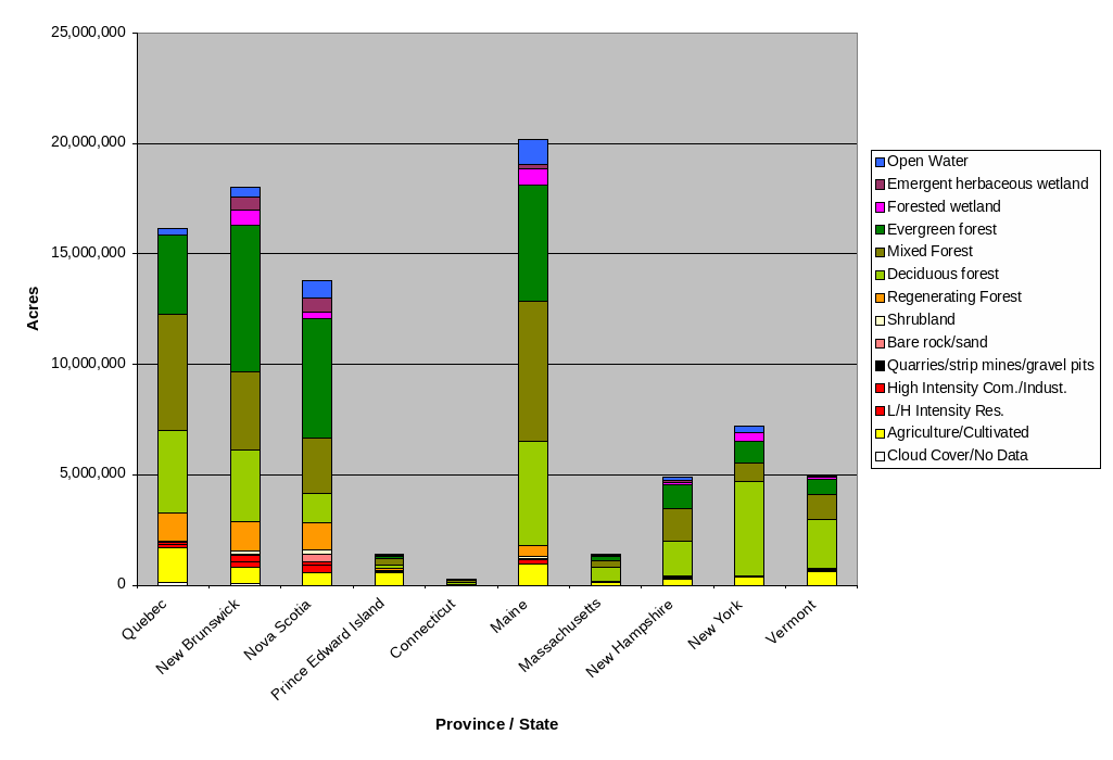
Figure 4. Acreage of land cover types within the BCR 14 portion of states and provinces.
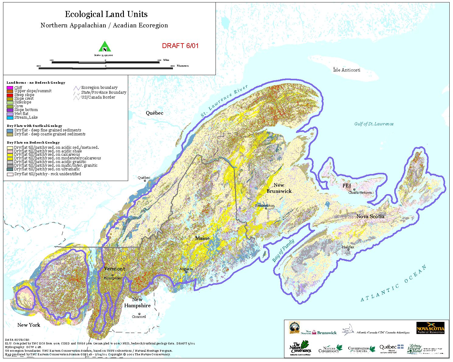
Figure 5. Map of Ecological Land Units in the Northern Appalachian Ecoregion, as defined by The Nature Conservancy.

Figure 6. Map of fine-scale ecological systems, which reflect a combination of land cover and ecological land units, for BCR 14.
Breeding Bird Survey (BBS) maps of bird distribution, relative abundance, and population trend – maps of these analyses, as well as raw data, covering Canada and the U.S. are available from the USGS Patuxent Wildlife Research Center’s BBS website. The BBS data are essential to almost all aspects of landbird conservation planning, and these data can provide useful information for some breeding species of other taxonomic groups. In addition to the standard maps and analyses available on the website, maps of distribution and trends at the scale of BBS blocks and 30-minute blocks have also been created to assist in addressing issues at finer scales. Contact John Sauer for more information about these additional analyses.
Bird-habitat models – several projects have been undertaken to model bird-habitat relationships within various parts of BCR 14. These efforts include models of bird distribution developed as part of the GAP Analysis efforts in each U.S. state (Maine, Vermont & New Hampshire, and New York). Another habitat modeling project that is applicable to BCR 14 is the Gulf of Maine Habitat Analysis developed by the USFWS Gulf of Maine office. This project developed models that relate bird occurrence to habitat types and landscape-level habitat configuration and then mapped predicted suitable habitat for species of concern throughout the Gulf of Maine watershed. Models for several BCR 14 priority bird species were applied across the U.S. portion of BCR 14 as a pilot project to see if these models were appropriate beyond the Gulf of Maine watershed. For selected priority species, TNC has developed preliminary models of bird distributions across the BCR based on BBS data and ecological systems data.
Waterfowl surveys and objectives – annual mid-winter waterfowl inventories are conducted by federal and state agencies to obtain annual indices of wintering waterfowl populations along the Atlantic Coast. Data and analyses are available from the USFWS Migratory Bird Data Center website. Waterfowl population objectives for different flyways are presented in the 2004 update of the North American Waterfowl Management Plan. Since many of the priority waterfowl species in BCR 14 are primarily migrating or wintering species in the BCR, the mid-winter inventories provide a means of tracking wintering population trends and distributions. However, surveys for breeding American Black Ducks and seaducks are conducted annually.
Shorebird
surveys and population estimates – regional assessments of
important sites for monitoring shorebird are being developed as part
of PRISM, which seeks to accomplish the monitoring goals of the U.S.
and Canadian shorebird conservation plans. Preliminary information
for the assessment of the North Atlantic region has been compiled
and is available
at
http://www.shorebirdworld.org/fromthefield/PRISM1.htm.
These assessments are based in large part on International
Shorebird Survey data, which are housed at the Manoment Center for
Conservation Biology and are also available for review. Contact
Stephen Brown for more information on shorebird survey data.
In
addition to survey data, shorebird population estimates have been
presented at the continental level in the Canadian
Shorebird Conservation Plan and the U.S.
Shorebird Conservation Plan, as well as at the
regional level in the Northern
Atlantic shorebird plan.
Waterbird surveys, population estimates, and site data – surveys of waterbird colonies along the Atlantic Coast have occurred regularly in both Canada and the United States. Summaries of these survey data for individual species, including regional population estimates, are part of the species profiles that have been completed through the regional waterbird planning process by MANEM. Summaries of waterbird sites by jurisdictions as well as site-specific data are also being compiled and made available on the MANEM website. Access to colonial waterbird survey data from the mid 1990s for Atlantic coast states, as well as some colonial waterbird atlas data from Canada and the U.S., is available on the Patuxent Wildlife Research Center waterbird database.
Landbird population estimates and objectives – with the completion of the Partners in Flight’s North American Landbird Conservation Plan (Rich et al., 2004), population estimates for landbirds are available at the continental, BCR, and jurisdictional scales. See the Population and Habitat Objectives section for discussion of landbird estimates pertaining to BCR 14. These estimates are based on extrapolations of relative abundance data from the Breeding Bird Survey and employ several simplifying assumptions about detection probabilities and about survey routes representing random samples of habitat within a geographic area. Correction factors for detection distances and time of day detectability were also calculated and applied to the population estimates. Details on the methods for deriving these population estimates are provided in Rosenberg and Blancher (In Press). Contact Ken Rosenberg for more information.
Breeding Bird Atlases – Breeding bird atlas projects have been completed for all the provinces and states within BCR 14. These efforts produce a snap-shot in time of the breeding distribution of all breeding birds within each jurisdiction. Atlas projects typically attempt to identify all birds that are breeding within every atlas block in a jurisdiction. Atlas blocks are the geographic areas that form the basic survey units – typically 25 km2 areas in the U.S. (Laughlin and Kibbe 1985, Adamus 1987, Andrle and Carroll 1988, Bevier 1994, Foss 1994, Petersen and Meservey 2003) but 100 km2 areas for the atlas efforts in the Maritime provinces (Erskine 1992) and Quebec (Gauthier and Aubry 1996). New York is currently conducting field work for its second breeding bird atlas, and interim data can be previewed on the New York State Breeding Bird Atlas website.
3.2. Species Prioritization
During the BCR 14 workshop held in Maine during December 2002, participants compiled lists of priority species organized by the four major taxonomic bird groups. Work on these lists began during a series of pre-meetings prior to the Maine workshop and then were revised further through email and phone conversations following the workshop to arrive at the current version, which integrates all bird groups into a single list. This list reflects the priorities already identified in the different bird initiative plans, as modified through the collaborative assessment process engaged in during and after the Maine workshop. For this list, three categories were used to identify priority species – Highest, High, and Medium - based on rules and criteria (Table 1) agreed upon at the Maine workshop, with some modification by each taxonomic group to accommodate differences among and special issues associated with each group. Appendix C, Part 1 provides the details on how the taxonomic groups applied the rules and criteria in Table 1 to come up with the resulting BCR 14 priority species list (Table 2). This approach to prioritization facilitated the assignment of species to categories based primarily on objective criteria, with each species being evaluated using information from the continental/national and regional bird conservation plans of the four major bird initiatives. However, additional subjective expert opinion was occasionally used to resolve situations where information was lacking, or where data from different parts of the BCR suggested quite different levels of abundance or concern. The categories reflect levels of priority for conservation action, but no ranking is assigned to the species within each category - all are simply considered as members of priority pools.
Table 1. Conservation priority categories for bird species in BCR 14.
|
Priority |
Criteria/Rule |
|
HIGHEST |
High BCR Concern and High BCR Responsibility and (High or Moderate Continental Concern) |
|
HIGH |
High Continental Concern and Moderate BCR Responsibility OR Moderate BCR Concern and High BCR Responsibility |
|
MODERATE |
Moderate BCR Concern and Moderate BCR responsibility OR High Continental Concern and Low BCR Responsibility OR High BCR Responsibility and Low BCR Concern |
A fourth category – Management Concern – was used to identify species for which management is deemed beneficial in order to reduce conflicts with humans, to improve ecosystem health, or to maintain recreational opportunities.
The BCR 14 Priority Species List (Table 2) currently contains a total of 103 species and should be a dynamic list that is revised periodically to reflect new information that becomes available over time. A data sheet has been completed for each priority species (except shorebird data sheets are still being completed). Each data sheet provides information on the species’ population status; the importance of BCR 14 to the species; conservation issues and threats in the region; monitoring, research and outreach needs; and suggested conservation objectives for its primary habitat type(s) and critical focus areas/sites. Data sheets are provided in Appendix C, Part 2 with links for individual species from the Priority Species List below.
Table 2. BCR 14 Priority Species List, with primary season/s of occurrence: breeding (B), migration (M), winter (W).
|
Highest Priority |
||
|
Common Eider (B,W) |
Piping Plover (B) |
|
|
Purple Sandpiper (W) |
||
|
Great Cormorant (B,W) |
Red-necked Phalarope (M) |
|
|
Semipalmated Sandpiper (M) |
||
|
American Black Duck (B,W) |
Wood Thrush (B) |
|
|
Canada Warbler (B) |
|
|
|
High Priority |
||
|
American Golden-Plover (M) |
Cape May Warbler (B) |
Red Knot (M) |
|
Red-necked Grebe (W) |
||
|
Arctic Tern (B) |
Chimney Swift (B) |
Red Phalarope (M) |
|
Black-bellied Plover (M) |
Common Nighthawk (B) |
Roseate Tern (B) |
|
Common Tern (B) |
Ruddy Turnstone (M) |
|
|
Black Guillemot (B,W) |
Rusty Blackbird (B) |
|
|
Black Scoter (W) |
Herring Gull (B,W) |
Short-billed Dowitcher (M) |
|
Long-eared Owl (B) |
Upland Sandpiper (B) |
|
|
Northern Gannet (B) |
Veery (B) |
|
|
Bobolink (B) |
Whimbrel (M) |
|
|
Boreal Chickadee (B,W) |
Purple Finch (B,W) |
|
|
Razorbill (B,W) |
|
|
|
Moderate Priority |
||
|
American Bittern (B) |
Common Loon (B,W) |
Peregrine Falcon (M) |
|
Atlantic Brant (M) |
Gray Jay (B,W) |
Pine Grosbeak (B,W) |
|
Atlantic Puffin (B,W) |
Greater Scaup (W) |
|
|
American Oystercatcher (B) |
Horned Lark (B) |
|
|
Bald Eagle (B,W) |
Horned Grebe (W) |
Ruffed Grouse (B,W) |
|
Bank Swallow (B) |
Hudsonian Godwit (M) |
Sanderling (M) |
|
Barn Swallow (B) |
Killdeer (B) |
Semipalmated Plover (M) |
|
Black-backed Woodpecker (B,W) |
Short-eared Owl (B,M) |
|
|
Least Sandpiper (M) |
Surf Scoter (W) |
|
|
Long-tailed Duck (W) |
Vesper Sparrow (B) |
|
|
Northern Flicker (B) |
Whip-poor-will (B) |
|
|
Northern Goshawk (B,W) |
Willet (B) |
|
|
Northern Harrier (B) |
Wilson’s Snipe (B) |
|
|
Boreal Owl (W) |
Northern Parula (B) |
Wood Duck (B) |
|
Brown Creeper (B,W) |
Ovenbird (B) |
|
|
Common Goldeneye (B,W) |
Palm Warbler (B) |
Yellow Rail (B) |
|
Management Concern |
|
|
|
Resident Canada Goose (B,W) |
|
|
|
|
|
|
|
Mallard (B) |
|
|
3.3. Priority Habitats and Species-Habitat Suites
Fifteen general habitat types were identified during the BCR 14 workshop as important for supporting one or more of the priority bird species during at least one of their life stages (Table 3). These habitats are either in need of critical conservation attention or are critical for long-term planning to conserve continentally and regionally important bird populations.
Table 3. Priority habitat types for BCR 14, with corresponding definitions and landcover classifications used in developing a landcover map for the region.
|
Habitat Type |
Definition |
Landcover Classification for mapping purposes |
|
Marine Open Water |
Open waters from 20 km off the coast out to the limit of 320 km for the Economic Exclusion Zone (offshore); Open waters within 20 km of the coast (nearshore) |
Open Water |
|
Estuaries and Bays |
Open water lacking any vegetation, or open water dominated by plants that grow principally at or under the surface of the water - within a protected bay or estuary |
Open Water |
|
Rocky Coastline (including islands) |
Exposed consolidated rocky shore with little persistent or non-persistent vegetation |
Bare rock/sand |
|
Unconsolidated Shore – beach, sand, and mudflats |
Sandy shores, exposed sand flats, sandspits and gravel beaches; areas dominated by particles smaller than sand with virtually no vegetation; range of flooding regimes possible |
Bare rock/sand |
|
Estuarine Emergent Saltmarsh |
Emergent marshes dominated by persistent and non-persistent vegetation – estuarine systems |
Emergent Herbaceous Wetland |
|
Freshwater Lakes, Rivers and Streams |
Open water lacking any vegetation, or open water dominated by plants that grow principally at or under the surface of the water – freshwater systems (lacustrine, riverine, palustrine) |
Open Water |
|
Palustrine Emergent Marsh |
Emergent marshes dominated by persistent and non-persistent vegetation – palustrine, riverine |
Emergent Herbaceous Wetland |
|
Forested Wetland |
Wetlands dominated by woody vegetation greater than 6 m tall |
Forested Wetland |
|
Deciduous Forest |
Forest dominated by deciduous trees |
Deciduous Forest |
|
Coniferous Forest |
Forest dominated by coniferous evergreen trees |
Evergreen Forest |
|
Mountaintop forest/woodland |
Forest and/or woodland occurring at high elevations |
Evergreen Forest |
|
Mixed Forest |
Forest with a mix of deciduous and coniferous trees |
Mixed Forest |
|
Shrub-scrub/ Early successional |
Shrub and/or sapling dominated uplands, or wetlands dominated by woody vegetation less than 6 m tall including bogs and shrub swamps |
Shrubland/ Cultivated or Transitional Barren |
|
Grasslands |
Native grasslands, pastures, hay fields and fallow fields |
Agriculture/Transitional Barren |
|
Urban/Suburban |
Land within municipalities, including a range of short non-native grass, shrubs, and a mix of deciduous and coniferous trees, as well as buildings and other structures providing nesting substrates |
Other grass/low intensity developed |
The priority species can be sorted according to the habitat types they use most frequently, forming Species-Habitat Suites for BCR 14 (Appendix D). The highest priority species do not form cohesive habitat groups, but rather are distributed among most of the different priority habitat types within this region. Therefore, no attempt is made in this document to rank these species-habitat suites. All priority habitat types support numerous priority species and require some level of conservation attention in order to maintain long-term, healthy populations of those priority species. It will be up to the collective BCR 14 partnership to prioritize among species-habitat suites, if it decides such prioritization is appropriate.
3.4. Population and Habitat Objectives
Ideally, population objectives should reflect the population levels necessary to maintain a high probability that a species will persist in the region for a long time. Also, habitat objectives should reflect the amount of habitat necessary to support the population levels of priority species set forth in the population objectives. Knowing what the relationship should be between a population objective and the corresponding habitat objective requires knowledge about how a species’ abundance and viability change as habitat conditions and quantities vary. Since our knowledge of these relationships is frequently incomplete or imperfect, the population and habitat objectives suggested at this time should be considered very rough and preliminary estimates and should be viewed with a sense of reality and skepticism. They will need to be updated and revised as better and more complete information on species-habitat relationships becomes available. Additionally, some species may not be limited by habitat availability during the breeding season, and for these species, conservation objectives addressing issues other than habitat should be developed to support the desired population goal.
It must also be recognized that for migratory species, population objectives are most meaningful for species whose primary season of occurrence in the BCR is during the breeding season. Estimating populations of migrating and wintering species in a region is complicated by the movements of individuals among locations and the interchange of individuals at any specific location during migration and within different parts of the wintering season. Also, annual variability in the numbers of birds either migrating through or wintering in a given location is often high. The relationships between local habitat conditions and abundance of birds is less direct during migration and wintering than during breeding because of the larger number of factors external to the local conditions that determine how many birds will pass through a particular area. Setting population objectives is also not very meaningful when it is difficult to estimate the size of the population using an area during the migration or wintering periods. Better methods for monitoring population sizes and trends using survey data from the migration and wintering period are necessary to improve our ability to set and monitor population goals for the migrating and wintering species in BCR 14, especially the shorebirds, waterfowl, and pelagic waterbirds.
Even with the many limitations that impact our ability to develop and evaluate progress toward population and habitat objectives, having even preliminary estimates for these objectives serves the purpose of informing the conservation delivery process as to what kind of actions need to be implemented to begin working toward achieving the goal of sustained populations of priority species. This concept has commonly been used by the major bird conservation initiatives in setting population goals at the continental level. The objectives set at the BCR scale should reflect a stepping-down of the continental level goals to a particular BCR and should indicate that region’s contribution to the overall continental goal. Likewise, BCR level objectives can be stepped down to smaller geographic areas such as jurisdictions or focus areas, with the contributions of all the smaller areas adding up to the overall BCR objective. The objectives set for BCR 14 reflect this approach. In addition, consideration should be given to the idea that population goals for smaller geographic areas are best defined in terms of demography-based objectives (e.g., reproductive rates, survival rates, body condition) rather than objectives for population size, which can be highly influenced by factors outside of small geographic areas.
Appendix E, Part 1 provides a detailed summary of specific conservation objectives and recommended actions from existing bird initiative plans, organized by priority species within priority habitats (i.e., species-habitat suites). The recommendations include estimates of current populations along with recommended population and habitat objectives where such information was available at the time of the current draft of this document. Appendix E, Part 2 breaks down specific population and habitat objectives from the BCR level to the contributions for which each jurisdiction is responsible in order to support the total BCR objective. Such population and habitat objectives have been proposed primarily for landbirds and waterfowl at this time, but the other bird groups are working on developing similar objectives. All such objectives presented in this document should be considered preliminary and in need of much further review and revision. They are provided mostly as suggestions for bird conservationists throughout the BCR to consider as initial conservation targets and to promote further discussions about objectives.
3 BIOLOGICAL FOUNDATION A KEY COMPONENT IN THE FRAMEWORK
3 GLOBAL TRAJECTORIES OF SEAGRASSES THE BIOLOGICAL SENTINELS OF
7 BSC 1005C BIOLOGICAL SCIENCES WITH LAB COURSE POLICIES
Tags: biological foundation, the biological, biological, framework, foundation, component
- Behavioral and Social Research Program nia Behavioral and
- FOTS MEETING TUESDAY 21ST APRIL 2015 630PM AT THE
- LEARN TO EARN PROGRAM WHAT IS LEARN TO EARN?
- REGISTRATION FILE FOR OPENFLUX PLEASE FILL IN THE FIELDS
- STATUT STOWARZYSZENIA „UNIA NADWARCIAŃSKA” ROZDZIAŁ I POSTANOWIENIA OGÓLNE §
- PROPOSAL FOR A ASPEN AND WHITE SPRUCE MIXEDWOOD MANAGEMENT
- POSTUP PŘI SCHVÁLENÍ UBYTOVÁNÍ PRO CIZINCE 1 ŽÁDOST O
- VEGETATION RECOVERY IN INLAND WETLANDS AN AUSTRALIAN PERSPECTIVE THIS
- COOPER COLLINS COOPERWCOLLINSSTUBAKERUEDU (785) 5948382 EDUCATION BAKER UNIVERSITY
- MALIYE BAKANLIĞI ILE SANAYI VE TICARET BAKANLIĞINDAN ARAŞTIRMA VE
- AL CONTESTAR REFIÉRASE AL OFICIO NO 8208 22 DE
- DEPARTMENT OF TOURISM HERITAGE AND CULTURE STRATEGIC INITIATIVES FUND
- PEMERIKSAAN PENUNJANG VERTIGO TES AUDIOLOGIK TIDAK DIBUTUHKAN UNTUK UNTUK
- SCHOOL CHESS CLUB LEVEL CRITERIA AND REGISTRATION FORM INTERNATIONAL
- MARK PUCCI MEDIA FOR IMMEDIATE RELEASE FEBRUARY 11 2010
- M AVWAHL 2021 UMFRAGE BITTE FAXEN AN 089
- ECO 207 SPRING 2007 EXAM 2 250 POINTS PLEASE
- GUIDELINES FOR COLLECTING PROCESSING AND SHIPPING MOLLUSKS PAGE 6
- MANIFESTO ARTS AND HEALTH PART 1 OVER THE PAST
- CONGRESO INTERNACIONAL “NUEVAS Y VIEJAS CUESTIONES DE LAS INVESTIGACIONES
- APPLICATION FOR SPLIT SEASON INSTREAM LEASE OREGON WATER RESOURCES
- „AŠ DŪSTU“ TOMAS VENCLOVA 423 METAIS PRIEŠ KRISTAUS
- STATEMENT OF RESPONSIBILITY IN TERMS OF THE PUBLIC FINANCE
- 7 CAPÍTULO 08 PREGUNTAS Nº 1 TIPO B BASES
- TC ÇEVRE VE ORMAN BAKANLIĞI DEVLET METEOROLOJİ İŞLERİ GENEL
- FICHE D’ENTRETIEN TÉLÉPHONIQUE – TRAVAUX SIMPLES OBJECTIF CETTE
- Hazardous Waste Storage Area Weekly Inspection Checklist Inspector Name
- HORARIO DE VERANO HORARIO VIGENTE DEL 18 DE SEPTIEMBREE
- LASTEN JA NUORTEN NEUROPSYKOLOGISTEN KUNTOUTUSPALVELUJEN HANKINTA MÄÄRÄAIKAAN 1572011 MENNESSÄ
- I DEFINICJE BIBLIOTEKA PUBLICZNA BIBLIOTEKA ZAŁOŻONA I FINANSOWANA
PODATEK OD ŚRODKÓW TRANSPORTOWYCH KTÓRE ŚRODKI TRANSPORTOWE PODLEGAJĄ OPODATKOWANIU?
 WALIKOTA GORONTALO PROVINSI GORONTALO KEPUTUSAN WALIKOTA GORONTALO NOMOR
  KANTONALES SOZIALAMT GRAUBÜNDEN UFFIZI DAL SERVETSCH SOCIAL CHANTUNAL DAL
VODE V SLOVENIJI – OCENA STANJA VODA ZA OBDOBJE
 ORDENSREGLER OG RETNINGSLINJER MEDLEMSKAB ALDERSGRÆNSEN FOR MEDLEMSKAB ER MIN
RZESZA WIELKA (RIEŠĖ) 1 AWŁASEWICZ WŁADISŁAW 18751929 2 AWŁASEWICZÓWNA
 UNCLASSIFIED NOMS ATTENDANCE CENTRE POLICY AND PRACTICE INSTRUCTIONS THIS
6 UNIVERSIDAD DE MENDOZA – FACULTAD DE INGENIERÍA CARRERA
 P ERU BUSINESS AGRARIO PRODUCCIÓN ORGÁNICA PRODUCCIÓN ORGÁNICA EL
 “THE NAMES” BY BILLY COLLINS DEFINE THE UPPERCASE UNDERLINED
PARAGRAPHING ACHIEVING TEXT COHESION WITH LINKING WORDS AND PHRASES
 FACULTEIT WETENSCHAPPEN EN BIOINGENIEURSWETENSCHAPPEN GEBOUW F VERDIEPING 4
 1 HAILSHAM TOWN COUNCIL RISK MANAGEMENT STRATEGY AND
EL INSTITUTO DE EDUCACIÓN SECUNDARIA “FERNÁNDEZ VALLÍN” ALUMNOSAS QUE
ANNUAL BULLETIN LOUIS PUBLIC COMPANY LTD 1 LOUIS PLC
AURORA BERTRANA PARADIGMA D’INTEL·LECTUAL CATALANA I EUROPEA ISABEL MARCILLAS
“LA PASIÓN POR LOS PERDIDOS” (2 CORINTIOS 511 –
 SLOBODA IZRAŽAVANJA – PRESUDE EVROPSKOG SUDA ZA LJUDSKA
 KINDERJUGEND & POLITIK INFORMATIONSKOMPETENZ UND POLITISCHE BILDUNG PROJEKTBERICHT TITEL
 UNIDAD DIDÁCTICA OBJETIVOS DE APRENDIZAJE 1 LOS NÚMEROS DESDE
