PERCENT FEDERAL LAND FOR OILGAS FIELD OUTLINES THE VBA
(THIS WRITTEN REPORT IS WORTH 40 PERCENT OF THE10 PERCENT BASELINE REDUCTION ISSUE NONLVC SUBMISSIONS TO THE
2006 PERCENTAGES AND COMPREHENSIVE ACT SCORES REPORTED BY ADE
ALEKS MINIMUM TARGET NUMBERS (PERCENT AND HOURS PER WEEK
ALLOCATE BY PERCENTAGE ON VOUCHERS PURPOSE THERE ARE TWO
ANEXO I – RELAÇÃO DE PRODUTOS E PERCENTUAIS ITEM
PERCENT FEDERAL LAND FOR OIL/GAS FIELD OUTLINES
PERCENT FEDERAL LAND FOR OIL/GAS FIELD OUTLINES
The VBA code below calculates the area percent of a first polygon layer (e.g. oil/gas field outlines) that are within a second polygon layer (e.g. federal land) and writes out the fraction as an attribute for the first polygon layer. If you make buffered well field outline polygons using the VBA code in BUFFERED_WELL_FIELD_OUTLINES.doc, you will have a feature class with the attribute PCTFEDLAND to use as the first polygon layer. If not, add the field PCTFEDLAND (double) to your polygon layer. You can insert multiple layers of federal land into a group layer named Federal_land as your second layer.
Copy the code into a VBA module in ArcMap.
Inputs:
Data frame in ArcMap named “Task 2”
Layer (0) is a reference layer of your choice
Layer (1) is the first polygon layer (e.g. buffered well oil-field boundaries) with a field “PCTFEDLAND”
Layer (2) is the second polygon layer, a group layer named "Federal_land" with sublayers each having federal land polygons in the display table
Output: Layer (1)'s PctFedLand column gets updated
Code by Kirk Kuykendall, AmberGIS; text by Sam Limerick, Z, Inc.
==============================================================
Option Explicit
Sub Task2()
'------------------------------------------------------------------
' Inputs:
' A dataframe named "Task 2"
' Layer (0) has a reference layer of your choice
' Layer (1) has buffered well polygons
' Layer (2) a group layer named "Federal_land" with sublayers each
' having federal land polygons in the "display table"
'
' Outputs:
' Layer (1)'s PctFedLand column gets updated
'------------------------------------------------------------------
' This module loop through each buffered oil field and
' updates the "PctFedLand" column by finding the total
' area of federal land from all layers in the group layer
' Note that merging all the coverages from these layers into
' one shape file or geodatabase can cause problems with
' "non-simple" geometry, preventing ITopologicalOperator.Intersect
' from working
'------------------------------------------------------------------
Dim pMxDoc As IMxDocument
Set pMxDoc = ThisDocument
Dim pMap As IMap
Set pMap = GetMap("Task 2")
If pMap Is Nothing Then
MsgBox "cannot find Task 2 dataframe"
Exit Sub
End If
Dim pWellBuffLayer As IFeatureLayer
Set pWellBuffLayer = pMap.Layer(1)
If pWellBuffLayer.FeatureClass.ShapeType <> esriGeometryPolygon Then
MsgBox pMxDoc.FocusMap.Layer(1).Name & " is not a polygon layer"
Exit Sub
End If
Dim pFedGroupLayer As ICompositeLayer
If Not TypeOf pMap.Layer(2) Is ICompositeLayer Then
MsgBox pMap.Layer(2).Name & " is not a group layer!"
Exit Sub
Else
Set pFedGroupLayer = pMap.Layer(2)
End If
Dim pSR As ISpatialReference
Set pSR = pMap.SpatialReference
Dim pInFCur As IFeatureCursor
Set pInFCur = pWellBuffLayer.FeatureClass.Update(Nothing, False)
Dim lPctCol As Long
lPctCol = pInFCur.FindField("PctFedLand")
If lPctCol = -1 Then
MsgBox "PctFedLand not found on " & pWellBuffLayer.FeatureClass.AliasName
Exit Sub
End If
Dim lNameFld As Long
lNameFld = pWellBuffLayer.FeatureClass.FindField(pWellBuffLayer.DisplayField)
Dim pInFeat As IFeature
Set pInFeat = pInFCur.NextFeature
Do Until pInFeat Is Nothing
Dim dTotalFedLand As Double
dTotalFedLand = 0#
Dim l As Long
Dim lLayersIntersected As Long
lLayersIntersected = 0
For l = 0 To pFedGroupLayer.Count - 1
Application.StatusBar.Message(0) = "... intersecting " & pInFeat.Value(lNameFld) & " with " & _
pFedGroupLayer.Layer(l).Name
Dim dFedLand As Double, pFedPoly As IGeometry
Set pFedPoly = GetFed(pInFeat.ShapeCopy, pFedGroupLayer.Layer(l), _
pMap.SpatialReference)
pFedPoly.Project pMap.SpatialReference
If Not pFedPoly.IsEmpty Then
lLayersIntersected = lLayersIntersected + 1
'modDraw.DrawGeometry pMxDoc.FocusMap, pFedPoly, vbRed
dFedLand = GetArea(pFedPoly)
' Debug.Print pFedGroupLayer.Layer(l).Name & ": " & dFedLand
dTotalFedLand = dTotalFedLand + dFedLand
End If
Next l
Dim dPctFedLand As Double, dBuffArea As Double
dBuffArea = GetArea(pInFeat.ShapeCopy)
dPctFedLand = dTotalFedLand / dBuffArea
Application.StatusBar.Message(0) = pInFeat.Value(lNameFld) & "," _
& Format(dPctFedLand, "00.0%") _
& ", Acres Fed Land: " & Format(dTotalFedLand, "000") _
& ", Acres OilGas Field: " & Format(dBuffArea, "0000") & ", "
pInFeat.Value(lPctCol) = dPctFedLand
pInFCur.UpdateFeature pInFeat
Set pInFeat = pInFCur.NextFeature
Loop
Application.StatusBar.Message(0) = "Task 2 finished"
End Sub
Function GetSRName(pGeom As IGeometry) As String
GetSRName = pGeom.SpatialReference.Name
End Function
Function GetSR(pFC As IFeatureClass) As ISpatialReference
' get the spatial reference from the geometry column
Set GetSR = pFC.Fields.Field(pFC.FindField(pFC.ShapeFieldName)).GeometryDef.SpatialReference
End Function
Function GetFed(pInGeom As IGeometry, pFLayer As IFeatureLayer, _
pOutSR As ISpatialReference) As IPolygon
' project the search geometry (well buffer polygon) into
' whatever the projection of the federal land featureclass is
pInGeom.Project GetSR(pFLayer.FeatureClass)
Simplify pInGeom
Dim pSF As ISpatialFilter
Set pSF = New SpatialFilter
Set pSF.Geometry = pInGeom
pSF.SpatialRel = esriSpatialRelIntersects
Dim pDispTable As IDisplayTable
Set pDispTable = pFLayer
Dim pFCur As IFeatureCursor
Set pFCur = pDispTable.SearchDisplayTable(pSF, False)
Dim pFedPoly As IGeometryCollection
Set pFedPoly = New Polygon
Dim pOutGeom As IGeometry
Set pOutGeom = pFedPoly
Set pOutGeom.SpatialReference = GetSR(pFLayer.FeatureClass)
Dim pFeat As IFeature
Set pFeat = pFCur.NextFeature
Do Until pFeat Is Nothing
Dim pPartPoly As IPolygon
Set pPartPoly = ClipPoly(pInGeom, pFeat.ShapeCopy)
If Not pPartPoly.IsEmpty Then
pFedPoly.AddGeometryCollection pPartPoly
End If
Set pFeat = pFCur.NextFeature
Loop
' Dim pOutGeom As IGeometry
' Set pOutGeom = pFedPoly
' 'pOutGeom.Project pOutSR ' project into utm
Set GetFed = pFedPoly
End Function
Function GetArea(pArea As IArea) As Double
Dim pGeom As IGeometry
Set pGeom = pArea
Dim pPCS As IProjectedCoordinateSystem
Set pPCS = pGeom.SpatialReference
Dim dFactor As Double
dFactor = pPCS.CoordinateUnit.MetersPerUnit * pPCS.CoordinateUnit.MetersPerUnit
Dim dAcresPerSqMeter As Double
dAcresPerSqMeter = 0.0002471
GetArea = dAcresPerSqMeter * dFactor * pArea.Area
End Function
Function ClipPoly(pTopoOp As ITopologicalOperator, pOtherGeom As IPolygon) As IPolygon
Dim pPolygon As IPolygon
Simplify pOtherGeom
Dim pGeom As IGeometry
Set pGeom = pTopoOp
Set pPolygon = pTopoOp.Intersect(pOtherGeom, esriGeometry2Dimension)
Simplify pPolygon
Set ClipPoly = pPolygon
End Function
Sub Simplify(pTopoOp2 As ITopologicalOperator2)
pTopoOp2.IsKnownSimple = False
pTopoOp2.Simplify
End Sub
ANNUAL TEACHING ACTIVITIES WORKSHEET (PERCENTAGE EFFORT ) A SCHEDULED
AUTOR JORDI RIBERA ORTIZ PERCENTATGES I TAULES DE DOBLE
BODY FAT PERCENTAGE AND LEVEL OF AEROBIC CAPACITY AMONG
Tags: federal land, the federal, oilgas, percent, federal, field, outlines
- PAJAMA SAM IN YOU ARE WHAT YOU EAT FROM
- FLASKEINNSAMLING UKE 9 OG 10 ~ 2009 HVER KORPSFAMILIE
- 6 COMMITTEE ON HEMISPHERIC SECURITY OEASERKXXIX OF THE PERMANENT
- 81 PRÍLOHA PROJEKTOVÉ VYUČOVANIE VÝCHODISKOM PROJEKTOVÉHO VYUČOVANIA
- FORM 64O COURTS OF JUSTICE ACT NOTICE OF REFERENCE
- PROTOKÓŁ Z POSIEDZENIA ZESPOŁU DS OCENY EFEKTÓW KSZTAŁCENIA Z
- UNIVERSIDAD DE MURCIA FACULTAD DE VETERINARIA ESTRATEGIAS NUTRICIONALES EN
- S VEUČILIŠTE U ZADRU ODJEL ZA ZDRAVSTVENE STUDIJE STUDIJ
- BOYS HOSTEL IS AVAILABLE OUTSIDE THE INSTITUTE CAMPUS (APPROX
- TRANSCRIPT UPRISING IN SLOVENIAEN 1) COULD YOU PLEASE
- ANEXO II ESPECIFICACIONES TÉCNICAS RENGLÓN Nº 1 333056570001
- CONSTITUTION OF THE BAPTIST CHURCH 1 NAME 1
- SHANGHAI SHIPPING EXCHANGE CODE LIST OF CONTAINER TYPE CONTAINER
- NIEUWE PORTAL BIEDT WEGWIJS IN MVWOUD SINDS 27 APRIL
- FRAGMENTO DE LA FUNDACIÓN DE ANTONIO BUERO VALLEJO TOMÁS
- CODIGO DGACCETAC003 ASUNTO PROCEDIMIENTO PARA LA CLASIFICACIÓN EVALUACIÓN ASIGNACIÓN
- 7 PROCESO Nº 31IP95 SOLICITUD DE INTERPRETACIÓN
- APPLICATION INFORMATION ADOBE ACROBAT 8 PROFESSIONAL ME VERSION IS
- PROTECCIÓN DE UN DISEÑO INDUSTRIAL VÍAS PARA REGISTRAR UN
- FORMULARZ RECENZJI ARTYKUŁU PRZEZNACZONEGO DO PUBLIKACJI W CZASOPIŚMIE „IUS
- LO QUE NECESITA SABER ACERCA DE SOBREGIROS Y CUOTAS
- THIS DOCUMENT PROVIDES DETAILS OF SPECIES IDENTIFIED AS BEING
- Repertoireliste Claus Kommerz Title ton Disc Singer Achy Breacky
- TİP SÖZLEŞME (YABANCI UYRUKLU ÖĞRETİM ELEMANLARI İÇİN) ERZİNCAN BİNALİ
- DWC008 TEXAS DEPARTMENT OF INSURANCE DIVISION OF WORKERS’ COMPENSATION
- DÁVÁ POŘÁD POZOR JESTLI DÁVÁM POZOR A KDYŽ SI
- GABRIEL LOZOYA ORTIZ CSALVAT PAPASSEIT Nº10 CASTELLAR DEL VALLÉS
- CHUYỆN HÔN NHÂN NỮ HOÀNG ELIZABETH II VÀ HOÀNG
- W HERE TO FIND EVENT DAY VOLUNTEERS ONLINE
- DATENSCHUTZHINWEISE FÜR KUNDEN INFORMATIONEN NACH ART 13 14 UND
MILITARY AND CIVILIAN RESOURCES BELOW IS A LISTING OF
 LEY QUE APRUEBA LA ADHESIÓN DE MÉXICO AL CONVENIO
 Steinmetz-Publikationen-Vortra%CC%88ge-Internet-7-2018
 Vicerreitoría de Investigación e Innovación Servizo de Convocatorias e
PROTOKÓŁ Z GMINNYCH ZAWODÓW SPORTOWO REKREACYJNYCH O PUCHAR
 OPERATION TIME METAN NTREAT MEANTREAT SDTREAT NCONT MEANCONT
VIZSGA TÉMAKÖRÖK KÖZBIZTONSÁGI REFERENSEK SZÓBELI VIZSGÁJÁHOZ 2012 SZEPTEMBER FELKÉSZÜLÉSI
WARSZAWA 01012018R WARUNKI UCZESTNICTWAUMOWA ŚWIADCZENIA USŁUG DROGĄ ELEKTRONICZNĄ W
VLOGA ZA UVELJAVITEV ŠTIPENDIJ IN DRUGIH ŠTUDIJSKIH POMOČI V
 SKIP TO PAGE CONTENT UNITED STATES DEPARTMENT OF VETERANS
 ONE EMPTY LINE 12PT HOW TO PREPARE THE FINAL
PROJEKAT UVRŠTAVANJE KONCEPTA MIGRACIJE I RAZVOJA U RELEVANTNE POLITIKE
EXPENDITURE REPORT PAGE 2 RETURN COMPLETED FORM TO SPECIAL
PYTANIA OBOWIĄZUJĄCE GRUPĘ III ( Z GRUPY I )
TITLE FACTORS PREDICTIVE OF AESTHETIC SUCCESS WITH TISSUE EXPANDERIMPLANT
LAW SCHOOL MEETS LITERATURE – PROFESSOREN STUDIERENDE UND ALUMNI
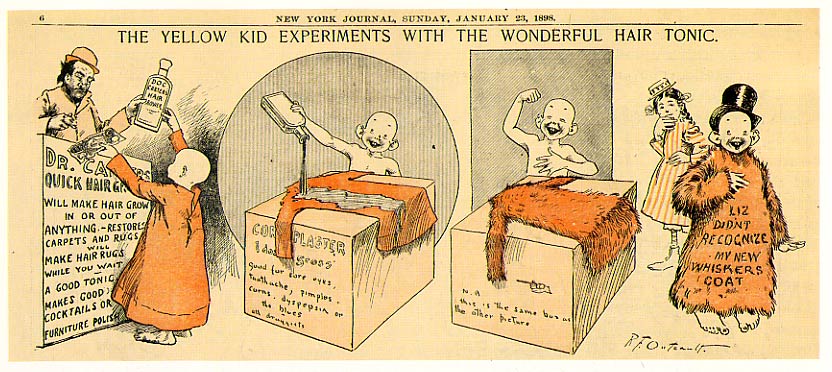 ANALYSIS POLITICAL CARTOONS – YELLOW JOURNALISM US HISTORYNAPP NAME
 QATARLEGISLATIONS DECREE LAW NO 14 OF 1982 DEPOSITING COMPILATIONS
CARTA ORGANICA PERICO IMPRESO Y EDITADO POR EL TRIBUNAL
 LESTVICE STALIŠČ LESTVICA MORA MERITI 1 SMER (SOGLAŠANJE ALI
