REMOTE SENSING RESOURCES FOLLOWING IS A LINK TO THE
use Remotely Piloted Vehicle Combines gps With Cadastral031822 25 INVESTIGATIONS OF REMOTE PLASMA IRREGULARITIES BY RADIO
1 DEFINE THE AFREMOTE SERVER TO THE COMMUNICATION MANAGER
1201-styremote
15 Optimizing File Replication Over Limitedbandwidth Networks Using Remote
1500 GPM REMOTE CONTROLLED AERIAL PLATFORM MONITOR TASK FORCE
Remote Sensing Resources
Remote Sensing Resources
Following is a link to the American Museum of Natural History remote sensing website. While this is by no means the only site for information on remote sensing, it is an excellent site to start from. It provides information on basic concepts, image interpretation, available data, and upcoming courses. It also includes tutorials, other training resources, and links to other sites.
Landsat 7 Data Users Handbook
http://landsathandbook.gsfc.nasa.gov/handbook.html A nice resource for using Landsat 7 imagery.
http://geospatial.amnh.org/remote_sensing
Here are several other interesting and helpful sites
LANDSAT Images of the U.S.A - Archive http://www.nasm.si.edu/research/ceps/rpif/landsat/LOYS.html An archive of Landsat 1-3 Multispectral Scanner imagery covering 48 states (excluding Alaska and Hawaii.) Indexed by U.S. states and cities.
Space Shuttle Photographs - Web Archive http://www.nasm.si.edu/research/ceps/rpif/sspr.cfm Includes shuttle photography of various locations throughout the world. Compiled by the Center for Earth and Planetary Studies (CEPS) unit within the Collections and Research Department of the National Air and Space Museum, Smithsonian Institution.
Geography
from Space
http://www.nasm.si.edu/geographyfromspace
Test your geographic knowledge using satellite imagery and Space
Shuttle and aerial photographs! Read the clue and try to determine
the geographic features visible in each image. Appropriate for upper
elementary and middle school.
Learning without Touching: What is Remote Sensing?
http://observe.arc.nasa.gov/nasa/exhibits/learning/learning_0.html A resource written for students featuring four lessons beginning with an overview of remote sensing, then an introduction to perspectives, concluding with remote sensing and its applications.
NASA Observatorium Education Resources http://observe.arc.nasa.gov/nasa/education/edu_index.shtml.html An extensive list of resources for teachers on remote sensing basics and online tutorials.
NASA Spacelink - An Aeronautics and Space Resource for Teachers http://www.nasa.gov/ A starting point to find educational materials on remote sensing and satellites. Includes search engine and library of NASA publications and web sites.
Included here is a list of sites that provide free remotely-sensed data and ancillary data.
Global Land Cover Facility (GLCF) http://landcover.org/data
SRTM DEM, MODIS Continuous fields, IUCN Protected Areas Database
NASA Stennis Space Center https://zulu.ssc.nasa.gov/mrsid/
1990 and 2000 Global Landsat Mosiac in MrSid format
Worldclim http://biogeo.berkeley.edu/worldclim/worldclim.htm
19 global bioclimatic variables at resolutions of 30 seconds (~1km), 2.5, 5, and 10 (~20km) minutes
Gridded Population of the World http://sedac.ciesin.columbia.edu/plue/gpw/index.html?main.html&2
Version 2 provides population estimates for the world in 1990 and 1995 at a resolution of 2.5 minutes (~5km)
USGS HYDRO1k dataset http://edcdaac.usgs.gov/gtopo30/hydro/index.asp
Several DEM derived layers such as slope, aspect flow direction, flow accumulation, basins, and streams at a resolution of 1km.
National Geospatial-Intelligence Agency (NGA – formerly NIMA)
http://geoengine.nga.mil/geospatial/SW_TOOLS/NIMAMUSE/webinter/rast_roam.html
VMAP level 0 (vector map of the world derived from 1:1,000,000 maps – this supersedes the Digital Chart of the World) and VMAP level 1 (vector map of much of the world derived from 1:250,000 although many of these data are not available for public distribution)
Geodata.gov http://www.geodata.gov/gos
A vast array of geospatial data for the USA
GEOnet Names Server (GNS) http://earth-info.nga.mil/gns/html/
Huge database of foreign (no USA names) geographic feature names. There are 4 million features in the database and it is updated regularly.
United State Environmental Protection Agency (EPA) Ecoregions http://www.epa.gov/wed/pages/ecoregions/level_iii.htm
EPA Level III Ecoregions of the conterminous United States
GIS Data Depot http://data.geocomm.com/
A variety of USA and global data
National Geophysical Data Center (NGDC) http://www.ngdc.noaa.gov/ngdcinfo/onlineaccess.html
A huge array of geophysical data including geomagnetism (great tool to computer compass declination for anywhere in the world), nighttime lights, marine, clouds, and a lot more.
Blue Marble http://earthobservatory.nasa.gov/Newsroom/BlueMarble/
Neat global MODIS mosaic
University of California at Berkeley Library http://www.lib.berkeley.edu/EART/vegmaps.html A list of URLs for online vegetation and plant distribution maps.
Open Topography http://www.opentopography.org/index.php Great data and software resources
Compiled by Bill Hegman, July 10, 2007
20080824%20Styremote
2ND INTERNATIONAL SYMPOSIUM RECENT ADVANCES IN QUANTITATIVE REMOTE SENSING
2ND PACIFIC OCEAN REMOTE SENSING CAPACITY BUILDING WORKSHOP ON
Tags: following is, following, resources, remote, sensing
- ……………………………………… KÉRJÜK NYOMTATOTT BETŰKKEL KITÖLTENI ! AZ ELJÁRÓ IRODA
- TABELAS DA NORMA DE QUALIDADE DA ÁGUA PARA CONSUMO
- KOMENTÁŘ KE ZMĚNÁM ZÁKONÍKU PRÁCE PLATNÝCH OD 112012 „NÁVRH
- SANDRA GROŠINIĆ OŠ D DOMJANIĆA SVETI IVAN ZELINA INTEGRIRANI
- CÁRITASEN KANPAINA 2012EKO ABENDUAREN 23 ABENDUKO IV DOMEKEA (C)
- RASPBERRY PI ADDA EXPANSION MODULE USER MANUAL RASPBERRY PI
- PROGRAMA DE ENTRENAMIENTO EN EL USO DE LA GUÍA
- NORMA BÁSICA DE LA EDIFICACIÓN NBECPI96 CONDICIONES DE PROTECCIÓN
- 2020 GUPPY SWIM PROGRAM DEL AMIGO’S GUPPY PROGRAM IS
- “ULOGA NEVLADINIH ORGANIZACIJA U IZGRADNJI POVJERENJA I DOBRE VLADAVINE
- FICHA RELEVAMIENTO DE TIPOS DE ALOJAMIENTO TIPO CATEGORÍA NOMBRE
- 2017 SPRING BEGINNING BASKETBALL SATURDAY LEAGUE “DD” DIVISION SADDLEBACK
- MODELO DE CERTIFICACIÓN PARA RENOVACIÓN DE ÓRGANOS SOCIALES DDª
- ZAŁĄCZNIK NR 11 DO WNIOSKU O DOTACJĘ NA DOFINANSOWANIE
- HANNELE IKÄHEIMO JA EIJA VOUTILAINEN 04032004 8(7) TEE PIIRRÄ
- NIH “INVESTIGATOR” FINANCIAL CONFLICT OF INTEREST (“FCOI”) DISCLOSURE FORM
- MŰSZAKI ELLENŐRI ÉSVAGY FELELŐS MŰSZAKI VEZETŐI TEVÉKENYSÉG ENGEDÉLYEZÉSE IRÁNTI
- FURTHER ACTION UNDER THE NHS AND SOCIAL CARE COMPLAINTS
- DEPARTAMENTO DE TECNOLOGÍA 20102011 PRÁCTICA 5 RAZONES TRIGONOMÉTRICAS Y
- ARBEITSSCHUTZ IN SCHULEN NRW CHECKLISTEN ZUR GEFÄHRDUNGSBEURTEILUNG VON LEHRERARBEITSPLÄTZEN
- 10 VAIRUOTOJO EKSPEDITORIAUS (ĮMONĖS PAVADINIMAS) PAREIGINIAI NUOSTATAI
- LA MAGIA DE LA LUNA DE JOSÉ ANTONIO MARTÍNEZ
- B ASHA HIGH SCHOOL BANDS CONCERT BAND SYLLABUS 1
- APRIL 2014 TEACHERS GUIDE FOR NAIL POLISH CROSSLINKED COLOR
- G UIDANCE FOR APPLICANTS BACKGROUND THIS GUIDANCE IS
- 0 APPLICATION FOR A LEIBNIZ DAAD RESEARCH FELLOWSHIP
- RAD N° 73001221300020170028201 ÁLVARO FERNANDO GARCÍA RESTREPO MAGISTRADO
- TÜRKİYE BİNİCİLİK FEDERASYONU YARIŞMA PROGRAMI KONTROL LİSTESİ VE PROTOKOL
- COMPUERTA CORTAFUEGOS BSKEN TEXTO DE ESPECIFICATIÓN COMPUERTA CORTAFUEGOS BSKEN
- AMERICAN INSTITUTE OF CERTIFIED PUBLIC ACCOUNTANTS COMMENTS ON NOTICE
CARTA ORGÁNICA PARTIDO MUNICIPAL “FRAILEÑOS UNIDOS POR EL CAMBIO”
DON QUIJOTE DE LA MANCHA “EN UN LUGAR DE
WHAT IS A PREFIX? A PREFIX IS A
EMOTIONAL DISTURBANCE TABLE OF CONTENTS DEFINITION INCIDENCE
 2TÉTEL A KERESKEDELEM HELYE ÉS SZEREPE A NEMZETGAZDASÁGBAN A
SOCIEDAD MINERA CORONA S A DECLARACIÓN DE RESPONSABILIDAD EL
GTBTNAUS89 3 NOTIFICATION THE FOLLOWING NOTIFICATION IS
 YOUNG AMBASSADOR REQUEST FORM PLEASE USE THIS FORM TO
 SKELBIMAS APIE SUPAPRASTINTĄ PIRKIMĄ PASLAUGOS PIRKIMO NUMERIS 89254 PERKANČIOJI
ACTIVIDADES PARA REALIZAR DURANTE EL PERÍODO DE DOS SEMANAS
 JOSÉ ORTEGA Y GASSET CREER Y PENSAR I LAS
4 P R O T O K Ó Ł
 SHORTTERM LICENCE SECTION 220 CROWN LAND MANAGEMENT ACT 2016
COMUNICACIÓN DE EXTINCIÓN DEL CONTRATO DE TRABAJO POR NO
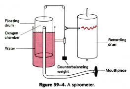 PULMONARY FUNCTION TESTS SPIROMETRIC PATTERNS IN CHRONIC OBSTRUCTIVE AND
UNA CAMPAÑA POR LECHE FRESCA “LA LECHE DE FRESCA
COFESAACTA 0111ANEXO I I REUNIÓN ORDINARIA DEL CONSEJO FEDERAL
FOGLIO ILLUSTRATIVO INFORMAZIONI PER L’UTILIZZATORE NOVASTAN 100 MGML CONCENTRATO
ZAŁĄCZNIK NR 2 SZCZEGÓŁOWA OFERTA CENOWA NAWIĄZUJĄC DO ZAPROSZENIA
 ZAPYTANIE OFERTOWE BP 12018 DOTYCZĄCE REMONTU LOKALU NIEZBĘDNEGO DO
