DOCKET NO 406 – UNITED ILLUMINATING COMPANY APPLICATION FOR
090321%20Updated%20CR%20Docket11 ORDER DOCKET NO 201066 STATE OF MAINE PUBLIC
157R10487 DOCKET NO 157R10487 BETTY HANSHAW AND +
4 DOCKET NOS RM018000 AND ER022001000 UNITED STATES OF
59 DOCKET NO ER031102000 106 FERC ¶ 61179 UNITED
6 DEPARTMENT OF HOUSING AND URBAN DEVELOPMENT [DOCKET NO
DOCKET NO
|
DOCKET NO. 406 – United Illuminating Company application for a Certificate of Environmental Compatibility and Public Need for the construction, operation and maintenance of a telecommunications facility located at 100 Marsh Hill Road, Orange, Connecticut. |
}
}
}
|
Connecticut
Siting
Council
January 20, 2011 |
Findings of Fact
Introduction
The United Illuminating Company (UI), in accordance with provisions of Connecticut General Statutes (CGS) § 16-50g through 16-50aa, applied to the Connecticut Siting Council (Council) on September 3, 2010 for the construction, operation and maintenance of a wireless telecommunications facility, which would include a 100-foot tall self-supporting lattice tower, at 100 Marsh Hill Road in the Town of Orange, Connecticut. (UI 1, pp. ES-1, 1)
UI is a specially chartered Connecticut corporation that provides electricity and energy-related services to customers in seventeen cities and towns in southern Connecticut. Its principal office is located at 157 Church Street, New Haven, Connecticut 06506. (UI 1, pp. 2-3)
The party in this proceeding is the applicant. (Transcript, November 16, 2010, 3:00 p.m. [Tr. 1], p. 3)
The purpose of the proposed facility is to facilitate operations and internal communications between UI’s Operations Center to be located at 100 Marsh Hill Road in Orange and the company’s field crews and remote electric system devices that are responsible for operating and maintaining the electric transmission and distribution system within UI’s service territory. (UI 1, p. ES-1)
Pursuant to CGS § 16-50m, the Council, after giving due notice thereof, held a public hearing on November 16, 2010, beginning at 3:00 p.m. and continuing at 7:00 p.m. in Orange, Connecticut. (Tr. 1, p. 2 ff.)
The Council and its staff conducted an inspection of the proposed site on November 16, 2010, beginning at 2:00 p.m. The applicant flew a balloon at the site from 7:30 a.m. until approximately 5:00 p.m. to simulate the height of the proposed tower. Winds were relatively calm until shortly before the field review. For most of the day, weather conditions afforded visibility of several miles. Weather conditions deteriorated later in the day with light drizzle and cloudy conditions. (Tr. 1, pp. 22 ff)
Pursuant to CGS § 16-50l(b), UI published public notice of its intent to submit this application on August 27 and 28, 2010 in The New Haven Register and on September 3 and 4, 2010 in The Connecticut Post. (UI 1, p. 4; UI 4, Attachment B – Affidavits of Publication)
Pursuant to CGS § 16-50l(b), UI sent notices of its intent to file an application with the Council to each person appearing of record as owner of property abutting the property on which the proposed tower would be located. In addition to abutting property owners, UI sent notices to owners of property from which the proposed tower might be visible. (UI 1, pp. 4-5; Attachment 6; Tr. 1, pp. 29-30)
Of 33 letters sent to nearby property owners, UI received 30 certified mail receipts. UI re-sent its letter of notice to the three property owners from whom return receipts were not received via first class mail. (UI 2, Answer to Interrogatory CSC-1)
Pursuant to CGS § 16-50l (b), UI provided copies of its application to all federal, state and local officials and agencies listed therein. (UI 1, p. 4; Attachment 6)
UI erected a four-foot by six-foot sign notifying the public of its pending certificate application with the Council near the entrance to the property on which its proposed facility would be located on November 1, 2010. The sign included the date and location of the public hearing and contact information for the Council. (UI 4, pp. 1-2)
State Agency Comment
Pursuant to CGS § 16-50l, on September 29, 2010 and November 17, 2010, the Council solicited comments on UI’s application from the following state agencies: Department of Agriculture, Department of Environmental Protection (DEP), Department of Public Health, Council on Environmental Quality, Department of Public Utility Control, Office of Policy and Management, Department of Economic and Community Development, the Department of Transportation (DOT), and the Department of Emergency Management and Homeland Security. (CSC Hearing Package dated September 29, 2010; CSC Letter to State Department Heads dated November 17, 2010)
The Council received a letter from the State Historic Preservation Office regarding the results of a Cultural Resources Assessment Survey report prepared in conjunction with UI’s proposed facility. (Letter from State Historic Preservation Office dated August 30, 2010 —See Findings of Fact numbers 56 and 57)
The Council received correspondence from the Drinking Water Section of the Department of Public Health stating that it had no comments on UI’s proposed facility. (Letter from Department of Public Health, Drinking Water Section, dated October 4, 2010)
The Council received correspondence from the DOT stating that the Department had no comments on UI’s proposed facility. (Letter from Department of Transportation)
The Council received correspondence from the DEP’s Office of Environmental Review regarding the possibility that monk parakeets could be attracted to the proposed tower as a nesting site. (Letter from DEP Office of Environmental Review, dated November 8, 2101 — See Finding of Fact number 61)
The Council did not receive correspondence from any other state agencies from which it solicited comments. (Record)
Municipal Consultation
On June 5, 2010, UI commenced the 60-day municipal consultation process required under CGS § 16-50l(e) by filing a draft of its application and supplemental technical reports with the Town of Orange. (UI 1, p. 21)
UI also filed copies of its municipal consultation information with the Cities of Milford and West Haven as its proposed site is within 2,500 feet of both municipalities. (UI 1, pp. 21-22)
The Town of Orange did not identify any alternative sites or make any recommendations concerning the proposed site during the municipal consultation. (UI 1, p. 22)
UI did not receive any comments from the City of Milford or the City of West Haven during the municipal consultation period. (UI 1, p. 22)
At the Council’s public hearing, the First Selectman of Orange expressed the town’s support for UI’s proposed facility. (Tr. 1, pp. 5-7; Tr. 2, pp. 3-5)
The Town of Orange has expressed a possible interest in placing public safety antennas on UI’s proposed tower. (UI 1, p. 10; Tr. 1, p. 7)
If the Town of Orange were to put antennas on the proposed tower, it could do so at no rental charge. (Tr. 1, p. 18)
Public Need for Service
UI holds licenses from the Federal Communications Commission (FCC) authorizing it to provide wireless service for the purposes of internal communications and operations. (UI 1, p. 22)
UI owns and operates several radio systems that are necessary for the efficient, reliable, and safe operation of its electric system. Its mobile radio systems allow electric system dispatchers and emergency response personnel to communicate with UI’s field crews, providing for quick response to emergency situations and enhancing the safety of UI’s employees and the general public. (UI 1, p. 5)
The CONVEX radio system that would be part of UI’s proposed facility allows for emergency communications to UI’s substations and CONVEX (the Connecticut Valley Electric Exchange). (UI 1, p. 5)
UI’s proposed facility would include power factor correction and recloser systems that control and optimize power flow throughout UI’s electric system, thereby reducing costs and enhancing availability of energy supply to UI’s customers. (UI 1, p. 5)
UI’s customers would benefit from the proposed facility, which would enable UI to increase operational efficiencies and lower costs for consumers. (UI 1, p. 11)
Existing and Proposed Wireless Coverage
The proposed tower is designed to provide coverage comparable to that provided by UI antennas located at its existing Operations Center in Shelton. The existing antennas currently on UI’s headquarters in Shelton would be removed when UI moves to its new headquarters under construction in Orange. (UI 2, Answer to Interrogatory CSC-8; Tr. 1, pp. 15-17)
The antennas on the proposed tower would provide communications between the Operations Center and employees in vehicles who are servicing the distribution system, between UI and CONVEX, and between power generators and other utilities in the state. One function of the communications system would be to facilitate black start operations. Antennas on the proposed tower would also allow communications with substations if wire line communication is lost. (Tr. 1, pp. 23-24, 54)
The antennas would not be part of UI’s Supervisory Control and Data Acquisition (SCADA) system. (Tr. 1, pp. 23-24)
As part of a Business Continuity Plan, UI would have a backup site for its proposed facility in the event that it became inoperable. (Tr. 2, pp. 25-26)
Site Selection
UI did not consider any possible locations for its proposed facility other than at its new Operations Center at 100 Marsh Hill Road in Orange. (UI 1, pp. 9-10)
The location of the proposed tower on the Operations Center property was selected to avoid other properties or critical facility buildings in the unlikely event of a tower collapse. (UI 1, p. 9)
There are no equally effective feasible technological alternatives to UI’s proposed tower that would meet UI’s internal operations and communications needs. (UI 1, p. 9)
Facility Description
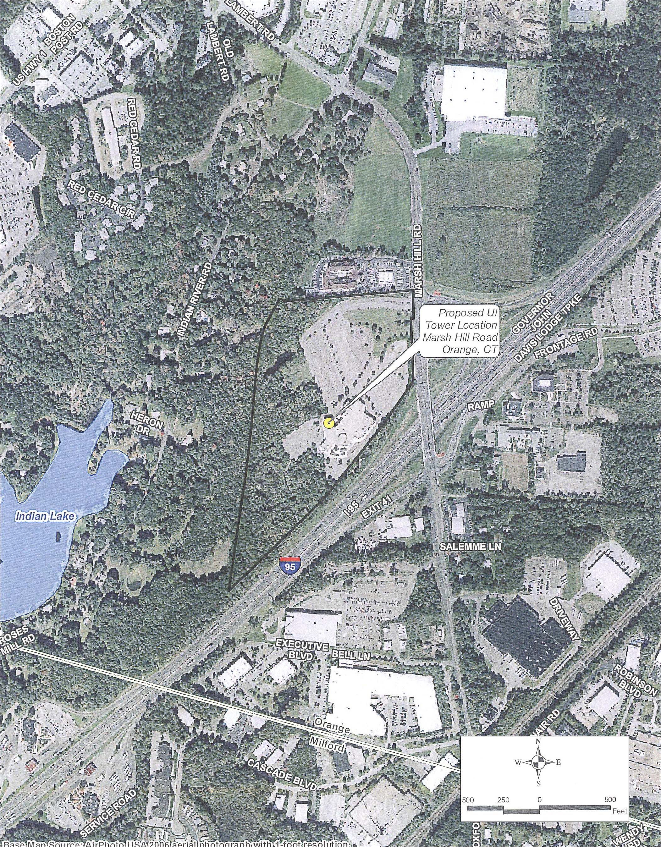
UI’s proposed site is on a 35-acre tract of land, comprised of two contiguous parcels, at 100 Marsh Hill Road in Orange, Connecticut. The tract is owned by UI and is the future site of its Operations Center for its Central Facility. (UI 1, pp. ES-1, 6)
UI’s tract is within a Light Industrial District 2 zoning district. Wireless telecommunications facilities are permitted in Light Industrial Districts with the granting of a special use permit. Light Industrial Districts are the most preferred location for wireless telecommunications facilities among the different zoning districts designated by the Town of Orange. (UI 1, p. 6; Bulk Filing – Orange Zoning, Sections 383-153 and 383-154)
The property on which UI’s facility would be located was previously developed as a multi-plex cinema, which was demolished by UI in June 2009. In October 2009, the Orange Town Plan and Zoning Commission approved an application from UI to construct its Operations Center on the former cinema site. UI’s Operations Center would consist of a four-story office building, a parking garage and parking lot, a field crew training area, and a service and maintenance area comprised of a maintenance building, fueling station, covered truck parking, indoor storage and an outdoor storage area for utility equipment. (UI 1, pp. 6-7)
Access to the property on which UI’s Operations Center will be located would be necessarily limited, according to requirements established by the Federal Energy Regulatory Commission (FERC), because the facility would be involved in managing the bulk transmission system. UI’s property will be enclosed by a fence and secured by a guard system. The FERC requirement for restricted access is one reason UI would be reluctant to allow commercial wireless carriers to share its proposed tower. (Tr. 2, pp. 13-15)
To comply with FERC requirements, UI’s property would be secured by an eight-foot perimeter fence on three sides and a six-foot high, decorative security fence along Marsh Hill Road and the main entrance drive. A small guard house would be located at a security checkpoint near the main entrance to the Operations Center. Access to the proposed facility would be through the Operations Center’s main entrance drive off of Marsh Hill Road. (UI 1, pp. 2, 7)
The western portion of UI’s property cannot be developed because it is protected by a conservation easement. This area is characterized by shrubs and woodland and wetland areas. The conservation area provides a forested buffer between what will be the developed portion of UI’s property and nearby residences along Indian River Road to the west of the proposed facility’s location. (UI 1, p. 6)
UI would erect a 100-foot tall, three-legged, self-supporting lattice tower. It would be located near the center of UI’s property, next to the southwest corner of the parking garage. A 15-foot by 22-foot by 11-foot high equipment shelter would be installed next to the base of the tower. (UI 1, ES-1, Attachment 8)
UI chose a lattice design for its tower because of cost considerations and because with a lattice tower, it would be easier to install additional antennas onto the legs of the tower as opposed to drilling through the tower or using bands to attach additional antennas or welding attachments onto the pole as would be the case with a monopole tower. (Tr. 1, pp. 25-26; 35-36)
The proposed tower and its associated equipment shelter would not be enclosed by a separate fence but would be within the larger fence surrounding the entire UI property being developed as its Operations Center. (UI 2, Answer to Interrogatory CSC-4)
The proposed tower would be seven feet wide at its base and would taper to a width of five feet for most of its height, including at its top. The proposed tower would be engineered to comply with EIA/TIA-222-F “Structural Standards for Steel Antenna Towers and Antenna Support Structures.” (UI 1, Attachment 1; UI 2, Answer to Interrogatory CSC-3)
The tower would be located at latitude 41° 15’ 11” north and longitude 73° 0’ 8.68” west. The ground elevation at the base of the tower is 104.9 feet above mean sea level. (UI 2, Answer to Interrogatory CSC-2)
UI would install up to ten antennas of various types—including dipole, omni-directional, and directional Yagi—on its proposed tower. The antennas to be installed would operate on UI’s VHF-Low Band mobile radio system, its UHF Meter Services mobile radio system, the Power Factor Correction (capacitor) control system, the CONVEX wireless communication systems, and possibly the Distribution Recloser control system. (UI 1, pp. 1, 8, 10)
Power to the proposed facility would be provided from the Central Facility Operation Center. (UI 2, Answer to Interrogatory CSC-9)
Backup power would come from the five 600-kW generators UI would have on site to provide emergency power for its entire facility. (Tr. 1, p. 22)
No blasting would be required to develop the proposed facility. (UI 2, Answer to Interrogatory CSC-10)
The proposed tower’s setback radius would be contained within UI’s property. (UI 1, p. 16)
There are two residences within 1,000 feet and 30 residences within 2,000 feet of the proposed tower’s location. (UI 1, Attachment 10; Tr. 1, p. 11)
The closest residence is located 942 feet to the west of the proposed tower’s location at 85 Indian River Road. It is owned by George, Basile, and Olympia Tzovolos. (UI 1, Attachment 10; UI 2, Answer to Interrogatory CSC-11; Tr. 1, p. 11)
Land uses in the vicinity of the proposed facility consist primarily of industrial, commercial, and highway uses. The closest residences are located to the west of the proposed facility and are separated by the forested conservation area. (UI 1, p. 10)
The estimated costs of the proposed facility, including antennas, are:
Radio equipment $239,705
Tower, coax, and antennas costs 22,000
Antenna foundation 15,000
Equipment shelter 40,000
Electric service for equipment shelter 15,000
Total costs $331,705
(UI 1, p. 24)
Environmental Considerations
Based on recommendations from the State Archaeologist and the State Historic Preservation Office, UI had a Cultural Resources Assessment Survey report prepared for its property on which the proposed facility would be located. (Letter from State Historic Preservation Office dated August 30, 2010)
The Cultural Resources Assessment Survey did not identify any historic properties within the Area of Potential Effects for the proposed facility. (Letter from State Historic Preservation Office dated August 30, 2010)
UI’s proposed facility would have no effect on historic, architectural, or archaeological resources listed on or eligible for the National Register of Historic Places. (Letter from State Historic Preservation Office dated August 30, 2010)
Although UI’s proposed facility is located within the Coastal Area defined by the Connecticut Coastal Management Act (CCMA), it is not within the Coastal Boundary, and no coastal resources would be affected by the proposed facility. (UI 2, Answer to Interrogatory CSC-12; Transcript, November 16, 2010, 7:10 p.m. [Tr. 2], pp. 11-12)
According to DEP records, the Eastern Box Turtle (Terrapene carolina carolina) may occur in the vicinity of UI’s proposed Office Building that would be located at 114 Marsh Hill Road—a separate parcel from the one on which the proposed tower would be located. (UI 1, Attachment 17 – Letter from DEP Bureau of Natural Resources, dated November 3, 2008)
DEP suggested that the lattice design of the proposed tower might attract monk parakeets, an invasive exotic species that builds very large stick nests that can weigh hundreds of pounds and create dangerous nuisances. DEP suggested that a monopole tower would be less attractive to the parakeets. (Letter from DEP Office of Environmental Review, dated November 8, 2010)
Because the proposed tower would be located at its Operations Center, manned by five to six hundred people, it would be under constant observation by UI personnel, who are very aware of the problems created by monk parakeet nests through its experience with the birds in its service area. (Tr. 1, pp. 19-21)
There are six wetland areas on UI’s Operations Center property. All but one of these areas are located within a conservation easement that was established at the time the construction of the former cinema was approved in 1993. (UI 1, pp. 20-21)
The one wetland area that is not within the conservation easement is not located within the area that would be developed for UI’s Operations Center. (UI 2, Answer to Interrogatory CSC-7)
The Town of Orange’s Inland Wetlands and Watercourses Commission approved UI’s application to build its Operations Center on the site of the former cinema on September 22, 2009. (UI 1, p. 20)
UI would establish and maintain appropriate soil erosion and sedimentation control measures, in accordance with the 2002 Connecticut Guidelines for Soil Erosion and Sediment Control established by the Connecticut Council for Soil and Water Conservation, in cooperation with the Connecticut Department of Environmental Protection, throughout the construction period of the proposed facility. (UI 1, p. 21)
UI’s proposed facility would not adversely impact wetlands and watercourses either on or off of its property. (UI 1, p. 21)
UI’s proposed facility is not located within an Important Bird Area as designated by the National Audubon Society. (UI 2, Answer to Interrogatory CSC-13)
UI’s proposed facility would comply with the U.S. Fish and Wildlife Service’s recommended guidelines for minimizing telecommunications towers’ potential for impacting bird species. (UI 2, Answer to Interrogatory CSC-14)
The proposed tower would not constitute an obstruction or hazard to air navigation and, therefore, would not require any obstruction marking or lighting. (UI 1, p. 23; Attachment 16)
The cumulative worst-case maximum power density from the radio frequency emissions from the operation of UI’s proposed antennas is 0.33% of the standard for Maximum Permissible Exposure, as adopted by the FCC, at the base of the proposed tower. This calculation was based on methodology prescribed by the FCC Office of Engineering and Technology Bulletin No. 65E, Edition 97-01 (August 1997) that assumes all antennas would be pointed at the base of the tower and all channels would be operating simultaneously, which creates the highest possible power density levels. Under normal operation, the antennas would be oriented outward, directing radio frequency emissions away from the tower, thus resulting in significantly lower power density levels in areas around the tower. (UI 1, p. 13; Attachment 12)
Visibility
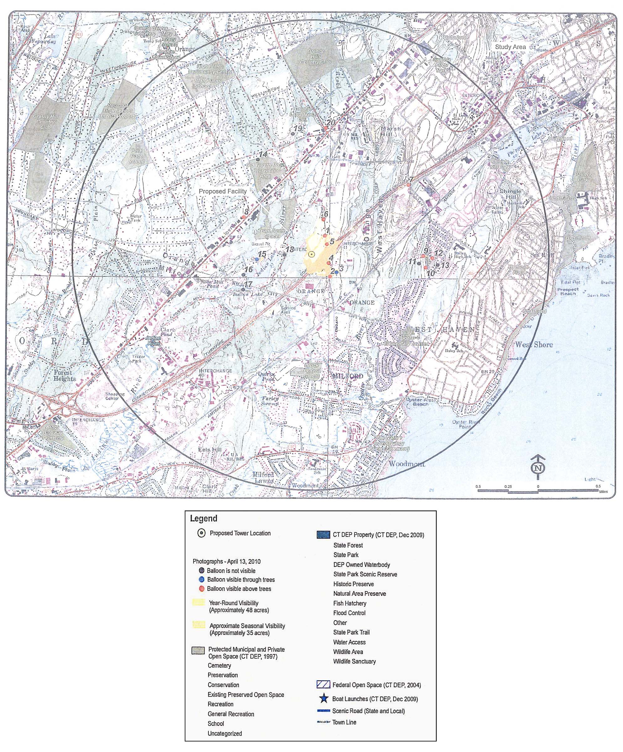
UI’s proposed tower would be visible above the tree canopy on a year-round basis from approximately 48 acres in the surrounding vicinity. Most of this visibility would occur on UI’s Operations Center property and its immediate vicinity (generally within .25 mile of the proposed tower’s location), primarily to the north and east along Marsh Hill Road. Residential views of the proposed tower would be minimal due to distance and intervening vegetation. The nearest residences to the west, located on Heron Road and Indian River Road, would not have views of the proposed tower. (UI 1, Attachment 11 – Visual Resource Evaluation Report, p. 5)
The proposed tower would be visible from at least portions of an estimated ten residential properties. Two of these properties are located on Marsh Hill Road; one property is located on Ridge Hollow Road; three properties are located on Island Lane; one property is located on Salamme Road; and three properties are located on Sunflower Circle. Most of these views would be located approximately one mile from the proposed tower and would be of the upper portion of the tower. The properties on Marsh Hill Road and Salamme Road, however, are located approximately 0.25 mile from the location of the proposed tower. (UI 1, Attachment 11 – Visual Resource Evaluation Report, p. 5)
No views of the proposed tower would be anticipated from town open space properties, the Old Tavern Road Recreation Area, or Long Island Sound. (UI 1, Attachment 11 – Visual Resource Evaluation Report, p. 5)
The proposed tower would be seasonally visible from approximately 35 additional acres. The areas of seasonal visibility are generally located south and east of the proposed tower’s site, including portions of UI’s Operations Center property, Marsh Hill Road, and I-95. (UI 1, Attachment 11 – Visual Resource Evaluation Report, p. 5)
Portions of approximately three additional residential properties would have seasonal views of the proposed tower. These properties are located approximately 0.9 mile to the east on Ridge Hollow Road and 0.5 mile to the west along Margaret Lane. (UI 1, Attachment 11 – Visual Resource Evaluation Report, p. 5)
The visibility of UI’s proposed tower from different vantage points in the surrounding vicinity is summarized in the following table. The vantage points listed are identified by their corresponding number in the Visual Resource Evaluation Report contained in Attachment 11 of UI’s application (Figure 4).
|
Location |
Site Visible
|
Approx. Portion of (100’) Tower Visible
|
Approx. Distance and Direction to Tower
|
|
1 – Marsh Hill Road, at entrance to UI property |
Yes |
80’ |
1,000 feet; SW |
|
2 – 65 Marsh Hill Road |
Yes |
60’ |
1,200 feet; NW |
|
3 – 10 Salamme Road |
Yes |
60’ |
1,400 feet, NW |
|
4 – Marsh Hill Road at Frontage Road |
Yes |
70’ |
850 feet; NW |
|
5 – Across Marsh Hill Road |
Yes |
90’ |
800 feet; SW |
|
6 – Marsh Hill Road |
Yes |
60’ |
1,600 feet; SW |
|
7 – Morgan Lane I-95 Overpass |
Yes |
30’ |
5,400 feet; SW |
|
8 – Route 1, southwest of Orange Center Road |
Yes |
20’ |
3,800 feet; NE |
|
9 – 6 Ridge Hollow Road |
Yes |
50’ |
5,000 feet; W |
|
10 – Toll Road and Island Lane |
Yes |
50’ |
5,000 feet; NW |
|
11 – Perry Merrin Drive |
No |
n/a |
4,800 feet; NW |
|
12 – 6 Sunflower Circle |
Yes |
10’ |
5,400 feet; W |
|
13 – 313 Benham Hill Road |
No |
n/a |
5,600 feet; W |
|
14 – Old Tavern Road Recreational Area |
No |
n/a |
4,800 feet; SE |
|
15 – 200 Margaret Lane |
Seasonal |
10’ |
2,400 feet; NW |
|
16 – 266 Mallard Drive |
No |
n/a |
3,100 feet; NE |
|
17 – 535 Roses Mill Road |
No |
n/a |
3,400 feet; NE |
|
18 – Heron Drive at Indian River Road |
No |
n/a |
1,100 feet; E |
|
19 – 322 Saybrook Road |
No |
n/a |
5,500 feet; SE |
|
20 – Racebrook Road at Route 1 |
Yes |
40’ |
5,700 feet; SW |
(UI 1, Attachment 11 – Visual Resource Evaluation Report, Photographic Simulations)
Figure 1: Site Location Map

(UI 1, Attachment 3)
Figure 2: Aerial Photograph of Site Location
(UI 1, Attachment 4)
Figure 3: Project Site Plan

(UI 1, Attachment 8)
Figure 4: Visual Analysis
(UI 1, Attachment 11)
AFFIDAVIT 2 DOCKET NO 201600084 STATE OF MAINE PUBLIC
ATTORNEY DOCKET NO ERROR REFERENCE SOURCE NOT FOUND ATTORNEY
BOARD OF LIQUOR LICENSE COMMISSIONERS FOR BALTIMORE CITY DOCKET
Tags: application for, ui’s application, united, docket, company, illuminating, application
- [ROO89] ROO+HIBERNATE+MYSQL PROBLEM WITH UTF8 SPECIAL CHARS CREATED
- ACTA FEDERACIÓN IBEROAMERICANA DE SOCIEDADES DE CATÁLISIS FISOCAT PORLAMAR
- Asunto se Solicita Corrección de Subdivisión Ezequiel Montes qro
- RL FACILITY REPRESENTATIVE PROGRAM APRIL 13 2000 SURVEILLANCE GUIDE
- MEMBERSHIP APPLICATION FORM THE BJC BOASTS A LARGE AND
- NAME INVERTEBRATE PHYLA NOTES PORIFERA PHYLUM A AN
- Nom Date Période Troisième Mission Saintpierre Quand Vous Allez
- M UNICIPALIDAD DE SOLOLA PROYECTO “MEJORAMIENTO DE LA 15
- MODEL STUDIES ON GEOFIBERREINFORCED SOIL IGC 2009 GUNTUR INDIA
- LEGEA NR 2782020 DIN 27 NOIEMBRIE 2020 PENTRU APROBAREA
- ASIAN MONSOON PREDICTABILITY IN JMAMRI SEASONAL FORECAST SYSTEM TAMAKI
- PLAN DE TRABAJO 5º B (JUEVES 19032020) LENGUA
- PAPIROFLEXIA PARA CURRÍCULO ADAPTADO PREPARADO POR EZEQUIEL VEMOS FORMAS
- DR JOSEPH L KENNEDY PRESIDENT SUNY CANTON 34 CORNELL
- 4 INSTRUCTIONS FOR LIHEAP HOUSEHOLD REPORT FOR FFY 2020
- 7 OPGAVER TIL EL HOMBRE QUE VEIA DEMASIADO
- CURSO DE POSGRADO “TÓPICOS ACTUALES SOBRE METABOLITOS SECUNDARIOS EN
- S ISTEMAS DE COMUNICACIONES OPTICAS UDABOL RECEPTORES OPTICOS 1
- APPENDIX 1 BIOFOULING MANAGEMENT PLAN APPENDIX 1 BIOFOULING
- ENRIQUE J MOREA BORN APRIL 11 1924 BUENOS AIRES
- ACT ACCOUNTING POLICY ACCOUNTING FOR PROVISION FOR MAKE GOOD
- ANDRAGOŠKO UČILIŠTE ZVONIMIR ORGANIZIRA OSPOSOBLJAVANJE ZA POSLOVNE TAJNICE (TAJNIKE)
- Checklist to File an Unlawful Detainer Action Step one
- 1 MEMORIA DESCRIPTIVA DEL PROCEDIMIENTO A) DENOMINACIÓN DEL PROCEDIMIENTO
- APPENDIX G NONCOLLUSION AND NONSUSPENSION STATEMENT THE UNDERSIGNED CERTIFIES
- EL AYUNTAMIENTO DE ………………… SOLICITA ASESORAMIENTO SOBRE LA TRIBUTACIÓN
- TDS DUOMENŲ VITRINOS „APSKAITOS KORTELĖS DUOMENYS” NAUDOTOJO DOKUMENTACIJA DUOMENŲ
- PRÀCTICA 1 (EXERCICI 2) REGULARITZACIÓ DEL TEXT PRÀCTICA 1
- PISANIE POZIOM PODSTAWOWY KILKA DNI TEMU ZWYCIĘŻYŁEŚ(AŚ) W ZAWODACH
- IGLESIA CATÓLICA SAN ISIDRO STEDMAN NORTH CAROLINA REGISTRACIÓN FAMILIAR
22 INTRODUCCIÓN LA UNIDAD DE PRÁCTICAS COMERCIALES INTERNACIONALES DE
 NOMBRE Y APELLIDOS DIRECCIÓN POBLACIÓN CÓDIGO POSTAL TELÉFONO
AZƏRBAYCAN RESPUBLİKASI ƏLYAZMASI HÜQUQUNDA ZAMAN BUDAQ CÜMLƏSİNİN FUNKSİONALQRAMMATİK XÜSUSİYYƏTLƏRİ
 UNIDAD DIDÁCTICA DE “JUEGOS MALABARES” PARA 4º DE LA
 d Eath in Service Policy 1 Introduction 11 Nottingham
 use Remotely Piloted Vehicle Combines gps With Cadastral
REVIEWED PAPERS SUBMISSION STRUCTURE TITLE IN BOLD (TIMES NEW
 E DUCACIÓN ESPECIAL REGISTRO DE PLANIFICACIÓN Y EVALUACIÓN DE
SUGGESTED CLASSROOM ACTIVITY FOR MN RTI CENTER PROGRESS MONITORING
 PARLAMENTO EUROPEO 2009 2014 COMMISSION{PETI}COMISIÓN DE PETICIONESCOMMISSION DATE{3132014}3132014DATE
 IMPRESO CAP MOMPÍA ESCUELA CLÍNICA MOMPÍA REGISTRO DE ALUMNOS
APPENDIX S1 COMMANDS USED IN THE COMPUTATION OF RIPLEY’S
 A OFFICE USE ONLY SIGNATURE OF APPROVAL BY DESIGNATED
 ZAŁĄCZNIK NR 1 DO UCHWAŁY NR…… ZARZĄDU WOJEWÓDZTWA LUBUSKIEGO
 CE 170 ENVIRONMENTAL ENGINEERING LAB PROCEDURES BIOCHEMICAL OXYGEN DEMAND
 HH_FT_044_003
DVADSATORO ODKAZOV RODIČOM OD ICH DETÍ 1 NEROZMAZNÁVAJTE MA
 PLAPLT0502 INSTRUCTIVO PARA REALIZAR REINTEGROS DE RECURSOS FINANCIEROS DE
5 LEY DE REORGANIZACIÓN DEL SECTOR PUBLICO PROVINCIAL
LOGITBOOSTNR ALGORITHMS FOR GENE SELECTION AND SAMPLE CLASSIFICATION FROM
